

Latest Weather Blog
A Sunny and Warm Friday
WATCH LIVE: Click here at 10 a.m. for a live weather update.
****
THE FORECAST:
Today and Tonight: Plenty of sunshine today, with dry conditions to wrap up the workweek. Temperatures will be warming into the 80s around 9 AM and 90s around 11 AM, on our way to an afternoon high of 92°. It will still feel rather hot though, as heat index values may reach near 102°. Winds should stay light and out of the north. A beautiful, clear evening tonight, but temperatures will be slow to cool. Overnight lows will eventually drop to around 70° into Saturday morning, and dewpoints will be making it into the upper 60s through the day on Saturday.
Up Next: Sunny and dry Saturday, but isolated showers and storms return on Sunday through Tuesday before conditions dry by midweek. Temperatures will be at or below average over the next 7 days.
Trending News
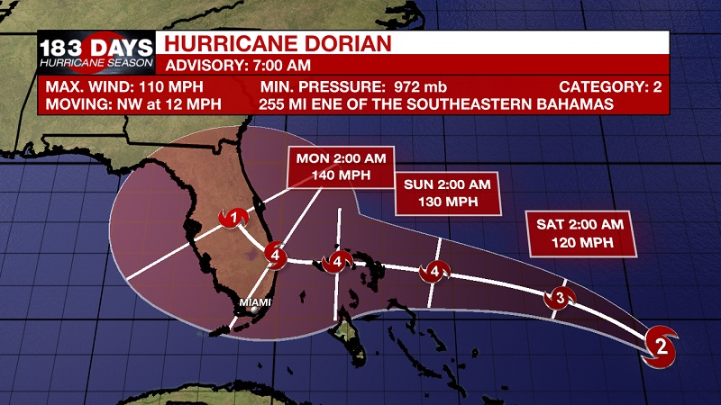
The Tropics: Dorian is currently a category 2 hurricane, and is forecast to become a major hurricane later today. It is located about 255 miles east-northeast of the Southeastern Bahamas and about 505 miles east of the Northwestern Bahamas. Sustained winds are now 110 mph and is moving northwest at 12 mph. A Hurricane Watch is in effect for the Northwest Bahamas. Dorian is moving toward the northwest near 12 mph, and this motion is expected to continue through the day. A slower west-northwestward to westward motion is forecast to begin tonight and continue through the weekend. On this track, Dorian should move over the Atlantic well east of the Southeastern and Central Bahamas today, approach the Northwestern Bahamas Saturday, and move near or over portions of the Northwestern Bahamas on Sunday. Data from an Air Force Reserve reconnaissance aircraft indicate that maximum sustained winds have increased to near 110 mph with higher gusts. Strengthening is forecast during the next few days, and Dorian is expected to become a major hurricane later today. Dorian is likely to remain an extremely dangerous hurricane while it moves near the Northwestern Bahamas and approaches the Florida peninsula through the weekend.
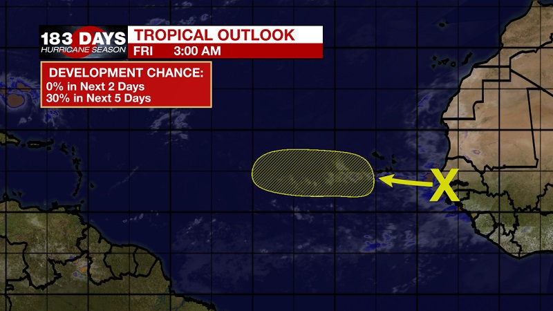
We are also tracking a tropical wave that is moving westward from the coast of Africa. Some development of this system is possible early next week over the eastern and central tropical Atlantic. The National Hurricane Center is forecasting a 0% chance of tropical development within the next 2 days, but that increases to a 30% chance over the next 5 days.
THE EXPLANATION:
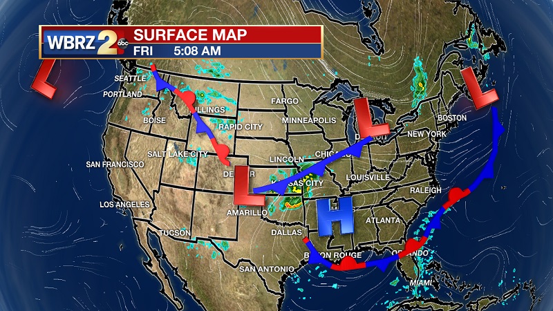
The frontal system that pushed through the Gulf Coast earlier in the week, has become stationary in the eastern Gulf of Mexico. The frontal boundary is oriented south to north over Cameron Parish, which could bring some afternoon showers over the western part of our state. High pressure stays through Saturday, before a surface low pressure currently over the Florida Keys helps to bring moisture back across our area as it gets pushed toward Alabama by way of Dorian. This low will also pull some Gulf moisture off of Dorian to keep rain chances elevated into Monday and Tuesday. Showers and storms should stay rather isolated, but some storm cells could incur heavy downpours and localized flooding. Dry air returns on Wednesday, as Dorian reinforces the frontal boundary over northern Louisiana and pushes it south. This will keep temperatures at or below average and skies sunny through the latter half of the workweek.
--Meteorologist Matt Callihan
The WBRZ Weather Team is here for you, on every platform. Your weather updates can be found on News 2, and the WBRZ WX App. on Apple and Android devices. Follow WBRZ Weather on Facebook and Twitter for even more weather updates while you are on the go.
More News
