

Latest Weather Blog
Tuesday evening video forecast
Related Story
After one more day of isolated showers and thunderstorms, a cold front will push through the area. Expect a noticeable drop in humidity and low temperatures.
Next 24 Hours: The overnight hours will remain partly cloudy with spotty showers. Low temperatures will be seasonably muggy for early September, dropping into the low 70s. With a weak front stationed across the southeastern half of the forecast area, isolated showers and thunderstorms will stay in the forecast on Wednesday but mainly for those locations closer to the front, south and east of Baton Rouge. High temperatures will be in the upper 80s.
Up Next: By Thursday, a more substantial cold front will push through the area. The atmosphere aloft will have already dried and the front may pass without much precipitation or even cloud cover. That drier air will work down to the surface as well and result in a stretch of pleasant weather. Through Saturday, expect mainly clear skies with highs in the mid to upper 80s and lows in the mid to upper 60s. By Sunday, a little moisture will stream back into the area and return isolated, afternoon showers and thunderstorms. CLICK HERE for your full 7-Day Forecast.
Y'all. Been two years... wanna #tailgate? ?? that forecast!#GeauxTigers #GeauxJags
— Josh Eachus (@DrJoshWX) September 7, 2021
Forecast --> https://t.co/emC0XZtDpL pic.twitter.com/aQwz2AVOj3
The Tropics: Powerful Hurricane Larry is expected to cause dangerous swells and rip currents from Bermuda, and across the Eastern Seaboard this week. With maximum sustained winds of 115mph, gradual weakening is expected over the next few days as Larry accelerates northwest and then north at 10mph.
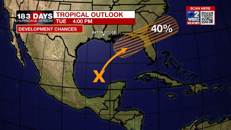
Showers and thunderstorms have increased today over the central Gulf of Mexico in association with a surface trough and an upper-level disturbance. The system is expected to move slowly northeastward over the northeastern Gulf of Mexico during the next couple of days. Upper-level winds are unfavorable, but they are forecast to become more conducive for some limited tropical or subtropical cyclone development as the system nears the northern Gulf coast on Wednesday and Wednesday night. The disturbance is then expected to cross the southeastern United States, and there is a 40 percent chance that a tropical depression could form after it emerges off the southeastern United States coast late this week.
For the latest tropical forecasts, advisories and information, visit the WBRZ Hurricane Center as we navigate all 183 Days of Hurricane Season.
The Explanation: An upper level trough centered over the Great Lakes region will slowly deepen and slide southeastward through the middle of the week. As this occurs, a cold front will be forced across the Southeast U.S. late Wednesday or early Thursday with an area of high pressure building into the Mid-South behind it. Through Wednesday, a weak boundary will be stalled across extreme southeast Louisiana and coast Mississippi. With ample tropical moisture pooled along this zone, scattered showers and thunderstorms will remain possible. Not to say some activity is impossible north of the front but the better chance, or coverage, of showers and thunderstorms will be closer to the coast. As the axis of that upper level trough and accompanying front swing into the region Wednesday night, the atmosphere will dry out with available moisture going below average for the time of year. From that point forward through Saturday, the dry air should win out to nix showers and thunderstorms. The drier air will also mean lower dew points and therefore lower low temperatures. Readings could slip into the 60s Wednesday night, but it is more likely that Thursday night and Friday night will have most inland locations dipping into the mid 60s. Recall that dry air warms more efficiently than humid air so highs will still be close to average in the upper 80s and low 90s.
--Josh
The WBRZ Weather Team is here for you, on every platform. Your weather updates can be found on News 2, wbrz.com, and the WBRZ WX App on your Apple or Android device. Follow WBRZ Weather on Facebook and Twitter for even more weather updates while you are on the go.
News
