

Latest Weather Blog
Monday evening video forecast
Related Story
Stubborn clouds and light winds will continue cold, gloomy conditions through Tuesday morning. While sunshine will return after that, the cold will hang around.
The Next 24 Hours: The low cloud deck will persist for most of the night. While this would normally cause low temperatures to stay up a few degrees, northerly winds coming from a region with fresh snow, will allow thermometers to dip below freezing. Additionally, the light north winds will cause chills, or feels-like temperatures, in the upper 20s. Some sun should start to break through during the day on Tuesday, allowing afternoon readings to reach the low 50s.
After That: Wednesday will also begin near freezing followed by afternoon sun and highs in the low to mid 50s. Highs have a shot at the 60s on Thursday before the next front sweeps through Friday. This one should pass by mainly dry but we will carry the mention of a stray shower in the forecast for now. Both weekend mornings could be frosty, in the low to mid 30s followed by partly sunny skies with highs in the upper 50s. CLICK HERE to view your complete 7-Day Forecast.
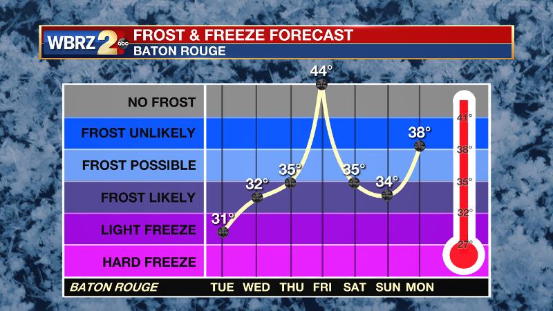
The Explanation: The area is trapped beneath a stubborn cloud deck that is unlikely to break anytime soon. This is because cold, northerly surface winds are trapped below warmer, southwesterly winds aloft. The result is condensation where these layers meets and therefore clouds. The southwesterly flow may abate some Tuesday allowing a few breaks of sun but not until another weak trough kicks through on Wednesday will much more sun appear. Monday night’s low temperature forecast is tricky due to the clouds. Normally, lows would be held higher than models suggest with overcast skies but because north winds are coming from a nearby snowpack, this should help nudge thermometers below freezing. A surface high will build into the region on Thursday allowing sun and seasonable temperatures. The next cold front will approach on Friday with a slight chance for showers. Behind this boundary, lows will again flirt with freezing both weekend mornings.
--Josh
The WBRZ Weather Team is here for you, on every platform. Your weather updates can be found on News 2, wbrz.com, and the WBRZ WX App on your Apple or Android device. Follow WBRZ Weather on Facebook and Twitter for even more weather updates while you are on the go.
News
