

Latest Weather Blog
Tuesday AM Forecast: Summer rain and humidity make a return
The muggies are back, and the rain came back with them.
THE FORECAST
Today & Tonight: Those fall conditions were nice while they lasted but there is still some summer left in the tank. Today is set to be gloomy and muggy. With thick cloud cover for most of the day, temperatures will max out in the low to mid 80s. Showers will be in and out all day, but most of the activity will be in the afternoon. Grab your umbrella and keep it close. Overnight temperatures will be in the low 70s.
Up Next: Another rainy day is on deck for Wednesday. Temperatures will max out in the low 80s with scattered showers and storms all day. A few heavy downpours and localized street flooding will be possible. Scattered showers will be the story again on Thursday with about half of the area expected to see some rain. Conditions will be humid with temperatures maxing out in the mid to upper 80s. Rainfall totals for the week are expected to be a manageable 1-3 inches, and some isolated higher amounts will be possible. Late week, the rain coverage will be much less with just a few showers around every afternoon. Temperatures will continue to trend in the mid-80s with high humidity. Click here to see the 7-day forecast.
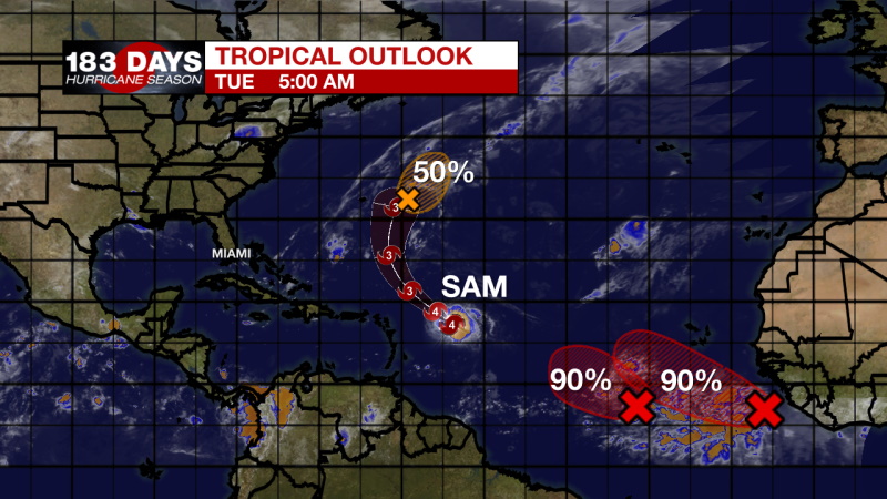
In the Tropics:
While there is a lot of activity in the Atlantic basin, none of it is currently a threat to the local area.
Trending News
A broad area of low pressure located several hundred miles southwest of the Cabo Verde Islands is producing a large area of disorganized showers and thunderstorms. Environmental conditions are conducive for further development, and a tropical depression is likely to form during the next day or two while the system moves westward to west-northwestward at 5 to 10 mph over the central tropical Atlantic. There is a 90% chance of formation in the next 5 days.
A tropical wave located over the far eastern tropical Atlantic several hundred miles southeast of the Cabo Verde Islands continues to produce a large area of disorganized showers and thunderstorms. Upper-level winds are conducive for gradual development, and a tropical depression is likely to form in a day or two while the disturbance moves westward to west-northwestward at 10 to 15 mph over the far eastern tropical Atlantic. There is a 90% chance of formation in the next 5 days.
A well-defined low pressure area associated with the remnants of Peter is located a few hundred miles east of Bermuda. The shower and thunderstorm activity associated with this system has become less organized since early Monday. Although strong upper-level winds are likely to prevent significant development, this system could still become a short-lived tropical depression later today or tonight while it moves northeastward at about 10 mph. By Wednesday, however, conditions are expected to become unfavorable for further development. There is a 50% chance of formation.
The WBRZ Weather Team is watching the tropics around the clock and will bring you updates as they come. Click here to visit the Hurricane Center.
Need weather conditions HOUR BY HOUR? Get hour by hour weather and right now weather conditions for your location on the WBRZ WX App on your Apple or Android device. Follow WBRZ Weather on Facebook and Twitter for even more weather updates and unique weather insight from the whole team!
More News
