

Latest Weather Blog
Tuesday AM Forecast: Humid conditions will last only through Thursday
The humid days are limited…
THE FORECAST
Today & Tonight: The summertime humidity is still here. Temperatures this afternoon will climb to an uncomfortable 88 degrees will all the humidity. Skies will be mostly sunny with only a stray shower possible. Overnight conditions will be clear with temperatures near 70 degrees.
Up Next: The summery pattern of muggies and a shower or two will continue through this week. Since the humidity will be high through Thursday, there will be enough moisture for a stray shower or two each afternoon. We are not tracking any washouts; most areas will stay dry. Temperatures will trend in the upper 80s and overnight lows will be near 70 degrees. As we approach the weekend, a cold front will bring increased rain coverage on Friday evening into Saturday morning. Behind this front, some cooler and drier air will settle in. High temperatures will be capped in the 70s starting on Saturday and overnight lows will dip into the 50s. All of that of course coming along with some lower humidity. Click here to see the 7-day forecast.
In the Tropics:
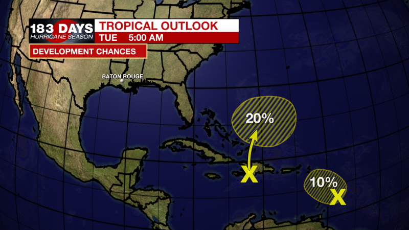
None of the activity in the tropics is a threat to the local area currently.
Trending News
Satellite-derived wind data indicate that the tropical wave, located a little over 150 miles east of the Windward Islands, has become less defined overnight. While this system continues to produce showers and thunderstorms primarily east of its center, strong upper-level winds will likely prevent further development during the next couple of days. Regardless of development, the system could produce locally heavy rainfall and gusty winds across portions of the central and northern Lesser Antilles today. Formation chance through the next 2 days is low, 10 percent.
Another tropical wave moving over Hispaniola is producing a large area of disorganized showers and thunderstorms. Although environmental conditions are not forecast to be conducive for development of this system, a broad area of low pressure, however, is expected to form near the southeast Bahamas on Wednesday and drift generally eastward through the end of the week. Regardless of development, locally heavy rainfall is possible over portions of the Lesser Antilles, Puerto Rico, and Hispaniola during the next couple of days. Formation chance through the next 5 days is low, 20 percent.
The WBRZ Weather Team is watching the tropics around the clock and will bring you updates as they come. Click here to visit the Hurricane Center.
Need weather conditions HOUR BY HOUR? Get hour by hour weather and right now weather conditions for your location on the WBRZ WX App on your Apple or Android device. Follow WBRZ Weather on Facebook and Twitter for even more weather updates and unique weather insight from the whole team!
More News
