

Latest Weather Blog
Thursday PM Forecast: weak front passing through area tonight
Beyond a weak cold front, a drier forecast is ahead for the Capital Area. Do not expect big changes in temperatures but the humidity may be a bit lower.
Next 24 Hours: A band of showers and thunderstorms will fall apart over the area tonight as a weak cold front creeps southward. As this front passes, winds will shift to the north and whisk some of the mugginess out of the air. Low temperatures will end up in the low 70s. Friday will be mostly sunny and warm. High temperatures will be in the low 90s, but humidity should be lower than earlier in the week.
Up Next: Since dry air warms easier than humid air, through Saturday, high temperatures will remain warm in the upper 80s and low 90s but nights will be a bit more comfortable. Low temperatures will slip below average in the upper 60s and low 70s. Rain chances will be very low through Sunday. Another weak cold front will come into the region next week and stall. As a result, scattered showers and thunderstorms will return. CLICK HERE for your full 7-Day Forecast.
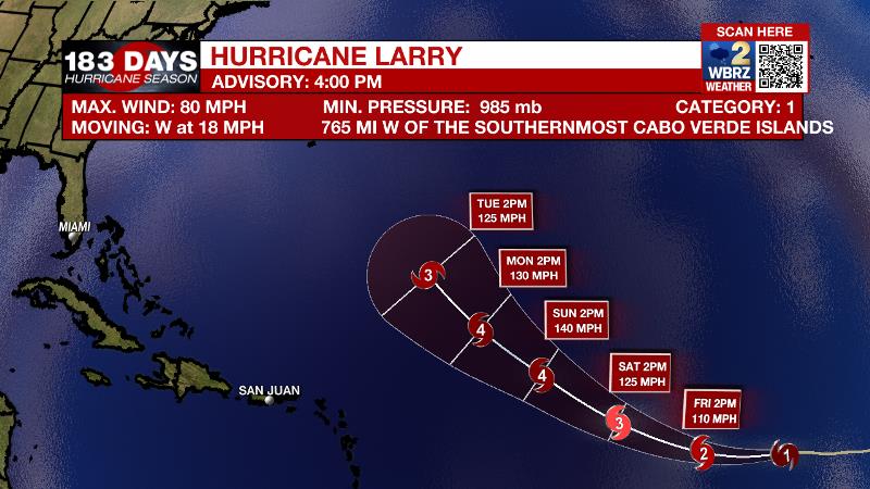
The Tropics: Hurricane Larry is getting steadily stronger and larger over the east, central Atlantic Ocean. With maximum sustained winds of 90mph, it will become a major hurricane by Friday. Moving to the west-northwest at 15-20mph, Larry is expected to slow down in the coming days and does not pose any threat to land at this time.
Trending News
A small area of low pressure over northeastern Nicaragua is producing disorganized shower and thunderstorm activity over portions of the western Caribbean Sea. There is just a 20 percent chance of formation when this system moves over the southwestern Gulf of Mexico early next week, because strong upper-level winds would likely limit significant development.
Showers and thunderstorms associated with an area of low pressure about 280 miles southeast of the southernmost Cabo Verde Islands continue to show signs of organization. There is a 30 percent chance of some development during the next 12-24 hours as the low moves generally westward at 10-15 mph. After that time, conditions are expected to become less conducive.
For the latest tropical forecasts, advisories and information, visit the WBRZ Hurricane Center as we navigate all 183 Days of Hurricane Season.
The Explanation: A weak cold front will move in from the northeast to spark a few more showers and thunderstorms through early evening. This feature should pass the local area with enough integrity to lower humidity as far south as I-10 by Friday morning. On the other side of that front, an upper level ridge will center over the central Gulf Coast states and dew point temperatures will dip into the 60s. This will, decrease rain chances, and lower humidity. However, since drier air warms more efficiently than humid air, high temperatures may be warmer than earlier in the week and the afternoon heat index will end up nearly the same. Fortunately, overnight lows will be a few degrees cooler, around 70 degrees. Within the drier air mass, rain chances will be barely above zero through the weekend. Another weak front is pegged to arrive early next week. Deeper moisture will pool ahead of it, returning humidity and elevating the chance of showers and thunderstorms.
--Josh
The WBRZ Weather Team is here for you, on every platform. Your weather updates can be found on News 2, wbrz.com, and the WBRZ WX App on your Apple or Android device. Follow WBRZ Weather on Facebook and Twitter for even more weather updates while you are on the go.
More News
