

Latest Weather Blog
Thursday PM Forecast: cold front moving through tonight
One more record high temperature occurred at Baton Rouge Metro Airport on Thursday, this time ousting the 2018 mark of 85 degrees. A cold front will push through the area leading to a 25 degree drop in temperatures.
Next 24 Hours: As a slow moving cold front sags south and east through the area, expect thicker clouds and scattered showers overnight. Once the boundary passes, winds will shift out of the north causing temperatures to steadily fall and end up near 50 degrees by dawn. Continued north winds and a persistent cloud deck will prevent much warming on Friday and high temperatures will likely stay in the mid to upper 50s. Showers may linger early Friday, but expect the area to dry during the afternoon.
Up Next: Skies will not fully clear out over the weekend. A stubborn cloud deck will stay overnight for Saturday with breaks of sun few and far between. This will keep temperatures in check with morning lows in the upper 40s and afternoon highs in the low 60s. A reinforcing front will come by with more clouds and isolated showers on Sunday. This front will be more progressive and provide drier, comfortable conditions for Lundi Gras and Mardi Gras. A mainly clear, dry and seasonable pattern is expected for most of next week. CLICK HERE for your detailed 7-Day Forecast.
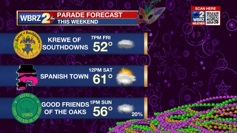
Local Mardi Gras Parades: The Krewe of Southdowns will roll with temperatures in the low to mid 50s on Friday night and although showers will be wrapped up, clouds will stick. Spanish Town can expect mainly cloudy skies around midday Saturday with temperatures in the low 60s. Krewe of Good Friends of the Oaks may have to dodge a stray shower during staging on Sunday morning but it should be drier but cloudy by parade time with temperatures in the upper 50s.
Trending News
The Explanation: A deeper upper level trough over the Western U.S. will race east and start to push a stubborn cold front through the area. A few showers will develop overnight into Friday. With minimal instability and weak upper level winds, thunderstorms are not expected. Some of these showers could linger across the area Friday as skies stay mainly cloudy. Cooler air will spill in behind the front as winds shift out of the north and this will cause temperatures to stay in the 50s for most of the day. The cold front will stall in the Gulf of Mexico while upper level winds stay out of the southwest. These winds flowing over the front will create a persistent cloud deck over the region on Saturday. A reinforcing cold front will swing through the area on Sunday with another pocket of clouds and showers. This one will send temperatures down a few more degrees into early next week, but more importantly, dry out the atmosphere just in time for carnival festivities Monday and Tuesday.
--Josh
The Storm Station is here for you, on every platform. Your weather updates can be found on News 2, wbrz.com, and the WBRZ WX App on your Apple or Android device. Follow WBRZ Weather on Facebook and Twitter for even more weather updates while you are on the go.
More News
