

Latest Weather Blog
Thursday PM Forecast: breezy and comfortable end to the week
Thursday morning began with low temperatures in the low 50s, the coolest readings since April. Comfortable conditions with lighter winds will continue through the weekend.
Next 24 Hours: Another cool night is ahead. With clear skies, north winds of 5-10mph and dew point temperatures in the upper 40s, lows will bottom out in the low 50s. Abundant sunshine is expected on Friday, which will help highs gradually warm into the low 80s. Out of the north at 5-10mph, the breeze will be much lighter than earlier in the week.
Up Next: Over the weekend, winds will continue to ease as temperatures gradually moderate about a degree or two per daypart. Expect highs in the low to mid 80s and lows in the mid to upper 50s. This trend will keep going next week. The atmosphere will stay relatively dry but contain just enough moisture for a cloud or two to form. Still, no rain chances are currently advertised through the middle of next week. CLICK HERE for your detailed 7-Day Forecast.
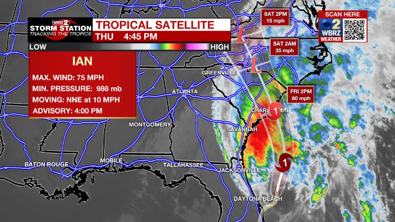
The Tropics: Hurricane Ian has moved over water again and will make a second landfall in South Carolina on Friday. As of 4pm, maximum sustained winds were at 75mph and the storm was moving north at 9mph. Ian will turning northwest on Thursday night and accelerating through landfall. Ian will rapidly weaken after that. Along parts of the South Carolina coast, storm surge of 4-6 feet is expected with hurricane conditions in Georgia, South Carolina and North Carolina. Some locations could receive up to 8 inches of rain and experience major river flooding.
Trending News
A tropical wave moving off the west coast of Africa is producing a broad area of showers and thunderstorms. Environmental conditions support a thirty percent chance of gradual development of this system through early next week as it moves westward to west-northwestward into the eastern tropical Atlantic.
The Explanation: Autumn weather will continue through the weekend. With Ian east of the area and a surface high pressure system to our north, a strong pressure gradient will continue to produce breezy conditions with northerly winds of 5-15mph. Those same winds continue to transport very dry air across the region with dew point temperatures in the 40s and low relative humidity. Very pleasant weather will continue with lows in the low to mid 50s and highs in the low to mid 80s. The associated dry air will result in zero rain chances through the middle of next week.
--Josh
The Storm Station is here for you, on every platform. Your weather updates can be found on News 2, wbrz.com, and the WBRZ WX App on your Apple or Android device. Follow WBRZ Weather on Facebook and Twitter for even more weather updates while you are on the go.
More News
