

Latest Weather Blog
Sunday Forecast: Widespread showers and storms back by Monday afternoon
The hot and dry conditions will be busted up by some afternoon showers and thunderstorms on Monday. Rain chances will linger through mid-week, perhaps assisted by some tropical moisture froma weak disturbance.
Tonight and Tomorrow: Overnight conditions will be muggy with temperatures near 73 degrees. The National Weather Service has issued another precautionary heat advisory on Monday. This afternoon the heat index will max out in the 90s with some areas in the triple digits. Take it slow while working outside and drink plenty of water. The best time to work outside will be between dawn and 10am or after 5pm. A weak front will squirm into the region and that will be plenty to ignite scattered or widespread showers and thunderstorms during the afternoon hours. Brief downpours leading to street and poor drainage flooding will be the main concern.
Up Next: Deeper tropical moisture will remain over the area on through Tuesday night. This will keep widespread showers and storms around on Tuesday afternoon. The rain will prevent temperatures from climbing too high. Temperatures will max out in the upper 80s and overnight lows will be in the low 70s. By later Wednesday, some drier air will work in from the north and rain coverage will be more concentrated near the coast. After that, humdiity should back down a notch in response to the drier air. Through the rest of the week, high temperatures will be in the upper 80s with low temperatures in the upper 60s. There are no rain chances advertised Thursday through Saturday. Click here to see the 7-day forecast.
In the Tropics:
A disturbance over the Yucatan is expected to increase rain coverage on the Gulf Coast for the first half of the week.
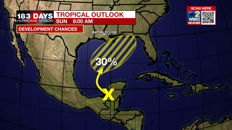
Disorganized showers and thunderstorms over portions of Central America and the Yucatan Peninsula are associated with a surface trough and an upper-level disturbance. Locally heavy rains are likely to continue today over that area. The system is forecast to move northwestward over the southwestern Gulf of Mexico later today, then move slowly northward or northeastward over the western or central Gulf of Mexico. This is the system that will increase rain coverage for the first half of the week in south Louisiana. Upper-level winds are only expected to be marginally conducive for tropical cyclone formation, but some slow development is possible while the system moves across the Gulf of Mexico through the middle of the week, 30%. It is possible that a tropical depression organizes, but it is unlikely that we see significant enough organization for this storm to be named.
Trending News
The WBRZ Weather Team is watching the tropics around the clock and will bring you updates as they come. Click here to visit the Hurricane Center.
Need weather conditions HOUR BY HOUR? Get hour by hour weather and right now weather conditions for your location on the WBRZ WX App on your Apple or Android device. Follow WBRZ Weather on Facebook and Twitter for even more weather updates and unique weather insight from the whole team!
More News
