

Latest Weather Blog
Hot, dry conditions locally as Dorian scrapes Southeast Coast
Some of the hottest temperatures of the year will occur through the weekend. Though dew points (humidity) will not be quite as high as July and August levels, the warmer temperatures will still produce dangerous heat indices.
THE FORECAST:
Today and Tonight: Mainly sunny skies will allow thermometers to reach the low 90s by midday. Expect a top out temperature near 96 degrees around 3pm. Winds will be light out of the east, northeast. Overnight, skies will stay clear with lows in the mid 70s.
Up Next: Dry and sunny conditions are expected for the rest of the week. This weather will be associated with a large upper level ridge of high pressure that will build across the Lower Midwest. This ridge helped protect the Gulf Coast from Hurricane Dorian. The ridge will stay around through the remainder of the week into Sunday. Light, northeasterly winds will keep slightly drier air in place. Drier air warms more efficiently than humid air, hence the well above average temperatures that are expected. One or two stations could tempt 100 degrees through Sunday. Rain coverage will be very low, with only a stray shower possible Friday, Saturday or Sunday.
Trending News
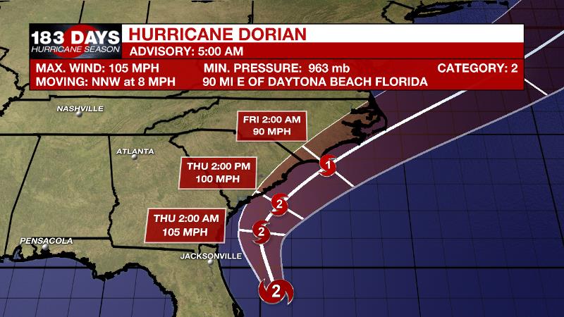
The Tropics: As of 5am Wednesday, Hurricane Dorian had moved away from the Bahamas parallel to the northeast coast of Florida. Maximum sustained winds were at 105 with a minimum central pressure of 963mb. A gradual north motion is anticipated to begin Wednesday. On the current forecast track, hurricane conditions will be very close to the coasts of Florida, Georgia and South Carolina but could remain just offshore. For coastal areas from Florida to North Carolina, storm surge of 4-8 feet is possible with rain amounts of 5-10 inches. Tropical Storm winds are possible there as well and a slight jog to the west by Dorian could result in much higher winds. In the southern Gulf of Mexico, Tropical Storm Fernand formed on Tuesday. Winds will top out around 45mph before the storm drifts westward into northeast Mexico and causes heavy rain. Tropical Storm Gabrielle also developed in the far eastern Atlantic, near the Cabo Verde Islands. Some strengthening is possible as the storm scoots northwest into the north, central Atlantic but Gabrielle will only be a fish storm.
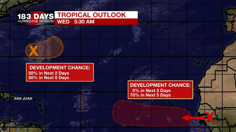
As we near the climatological peak of hurricane season, the Atlantic Basin is characteristically busy with several other areas being monitored for development. A wave in the central Atlantic, south of Bermuda has a medium chance of development as it drifts eastward. The next wave moving off the African Continent near the Cabo Verde Islands is also likely to become a named storm over the next week or so. Projected to take a more southerly track across the Atlantic Ocean, this one will at least merit some attention from the U.S. For the latest on the tropics, check in with wbrz.com/weather, WBRZ Weather on Facebook and Twitter.
THE EXPLANATION:
Winds over the local area are diverging, moving toward the lower pressure regions associated with Dorian and Fernand. Air sinks to fill the surface void which creates a warming and drying effect. That is the basic explanation for why the weather pattern is mostly dry with well above average temperatures. Temperatures have a shot at 100 degrees several times through the weekend. While dew point temperatures will be in the low 70s, rather than upper 70s normally felt in July and August, Heat Advisory feels-like temperatures could still be met some days due to the much higher air temperature. Dorian’s northeastward advance may push a weak cold front into the region Friday but with a very dry environment will barely allow a shower. Through Tuesday, little more than a rogue air mass shower or thunderstorm is possible, but rain coverage will stay very low.
--Josh
The WBRZ Weather Team is here for you, on every platform. Your weather updates can be found on News 2, wbrz.com, and the WBRZ WX App. on Apple and Android devices. Follow WBRZ Weather on Facebook and Twitter for even more weather updates while you are on the go.
More News
