

Latest Weather Blog
It'll feel like 100-105 degrees in some areas today; Watching the tropics
The heat advisory set earlier has been canceled. Temperatures and humidity levels are currently lower than originally expected. Though, heat index values may still rise to 100 to 105 degrees Monday afternoon, so continue to exercise caution during outdoor activities.
THE FORECAST
Today & Tonight: After some overnight rain, temperatures started near 70 degrees this morning. Even though we started a little cooler, temperatures will have no trouble heating into the mid 90s. The heat index will be between 100-110 degrees this afternoon. Practice good sun and heat safety today! A few showers will be around this afternoon, about 30% of the area will see rain today. Any showers will make a huge difference by dropping temperatures 10 to 15 degrees. Even if you don’t see any rain, a neighboring shower could provide some much needed shade from the sun.
Sun and Heat Safety: Some friendly reminders for your summer of fun events—sunburn can occur in less than 15 minutes with the extreme U.V. Index typical of this time of year. In addition to that, heat exhaustion and heat stroke can set in just as quickly. Seek medical attention if you or somebody you know is affected. While we all enjoy a list of cool beverages, be sure water is a part of that list! Finally, look before you lock. DO NOT leave people or pets in an unattended car.
Up Next: The hot and steamy afternoons are set to continue for the rest of the week. Temperatures will be in the 90s with heat index values near 100 degrees in the peak of the afternoon. Overnight temperatures will be in the mid 70s. Looking ahead to the weekend, tropical moisture is set to move in. Saturday and Sunday will likely be washouts with temperatures in the 80s. Click here to see the 7-day forecast.
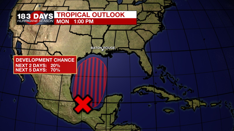
In the Tropics:
Trending News
Monday 1pm Tropical Outlook
The disturbance off the east coast of the US has formed into Tropical Depression Two. CLICK HERE to see the forecast cone.
Mid to late week the disturbance in the southern Gulf will become more organized. It has about a 70% chance of developing into a tropical depression in the next 5 days. Regardless of development, it is already a rain maker. Parts of Mexico will be dealing with tropical showers and storms for the first half of the week until the disturbance starts to track north. With the current forecast information, south Louisiana will likely see some tropical showers and storms by Friday afternoon with Saturday and Sunday setting up to be washouts.
Forecast information will become clearer as we get closer to the weekend, so please check back for new updates daily. Click here to visit the WBRZ Hurricane Center.
Need weather conditions HOUR BY HOUR? Get hour by hour weather and right now weather conditions for your location on the WBRZ WX App on your Apple or Android device. Follow WBRZ Weather on Facebook and Twitter for even more weather updates and unique weather insight from the whole team!
More News
