

Latest Weather Blog
Friday PM Forecast: scattered showers start to back down by end of weekend
Once again, showers and thunderstorms will be hit and miss on Saturday afternoon. Sunday and beyond, the area can expect a gradual decrease in daily precipitation.
Next 24 Hours: Some rain and thunder will linger into the evening hours before diminishing after midnight. Low temperatures will stop around 70 degrees. Some sun will be available early Saturday with high temperatures climbing into the upper 80s by early afternoon. Scattered showers and thunderstorms will be possible from late morning into late afternoon. For Tigers and Jags fans spending time out on campus, it will not be a total washout but you will want to have a safe option nearby in case of lightning or gusty wind from a passing thunderstorm. With regard to temperatures, there have been hotter and more humid home openers. With a kickoff temperature around 80 degrees, thermometers will drift into the mid 70s by the end of the game.
Up Next: Though a noticeable drop off in coverage is expected on Sunday, a stray shower and thunderstorm will be possible Sunday in the afternoon. On Monday, a weak front will push through the region. The upper levels will have already dried making showers and thunderstorms a bit more scarce than recently. Once the front passes, surface air will dry a bit too resulting in a few dry days, slightly lower humidity and lows in the upper 60s. CLICK HERE for your detailed 7-Day Forecast.
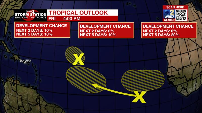
The Tropics: As of Friday afternoon, Hurricane Earl was 275 miles to the northeast of Bermuda packing 100mph winds and moving northeast at 20-25mph. Earl will continue speeding northeastward into the north Atlantic transitioning into a hurricane-force extratropical low this weekend. Swells from the storm may reach the Eastern United States.
Trending News
An area of low pressure located about 1000 miles east of the Leeward Islands is producing limited shower and thunderstorm activity, mostly displaced well to the northeast of the center of the low. Strong upper-level winds are expected to prevent significant development to ten percent as it drifts northwest before being absorbed by a front.
A tropical wave located several hundred miles south of the Cabo Verde Islands is producing a disorganized area of showers and thunderstorms. There is only a ten percent chance of development while it moves westward or west-northwestward at 15 to 20 mph across the eastern and central tropical Atlantic.
Another tropical wave is forecast to move off the coast of Africa by early next week. There is a twenty percent chance of gradual development of this wave will after it moves over water and heads generally westward over the far eastern Atlantic.
The Explanation: The stubborn upper level low, which has brought a few days of mostly cloudy, and at times stormy, weather, will begin to weaken on Saturday. While modeling suggests that moisture in the atmosphere will remain above average, a look at the water vapor imagery shows drier air trying to wrap into the system. This makes the forecast tricky because while the current moisture levels would support another day of showers and thunderstorms, if a pocket of drier air swoops in, a largely dry day would occur. If showers and thunderstorms do get going in response to the daytime warming, one or two storms could have briefly gusty wind or small hail. By Sunday, the upper low will be swept east in the jet stream, drastically lowering instability for showers and thunderstorms. Though not zero, rain coverage will be much lower for the second half of the weekend. Another shortwave trough of low pressure will move from the Midwest into the Great Lakes region early next week. At the surface, a weak low will lead the parent upper level system with a trailing cold front at the surface. This front is expected to extend and crawl southward into our area losing most of its identity along the way. However, some drier air aloft and at the surface (in the form of lower dew points) may start to filter into the region by Tuesday. As a result, even though afternoons will stay warm, morning low temperatures could get into the upper 60s. All of this is climatologically plausible for the time of year.
--Josh
The Storm Station is here for you, on every platform. Your weather updates can be found on News 2, wbrz.com, and the WBRZ WX App on your Apple or Android device. Follow WBRZ Weather on Facebook and Twitter for even more weather updates while you are on the go.
More News
