

Latest Weather Blog
As weak front falls apart, shower count goes down
A subtle change to the pattern is expected for the latter half of the week. However, the weather will be typical of summer along the Gulf Coast.
Next 24 Hours: The second round of showers and thunderstorms for the day will slowly diminish into the evening hours. After midnight, skies are expected to be mostly clouds. With calm winds and high humidity, low temperatures will only settle into the mid 70s. A slight tweak to the pattern is expected on Wednesday. As a weak front dissipates and retreats north, showers and thunderstorms will be more in need of daytime warming to develop. With that being said, some peeks of sunshine will send high temperatures into the low 90s allowing for a few afternoon rumblers.
Up Next: Thursday and Friday should feature typical summertime weather. Though the count of showers and thunderstorms will go down, the area will not be completely dry. Isolated, afternoon activity should pop-up both days. Thursday appears to be the least active afternoon. High temperatures will be in the low 90s with heat indices in the low 100s. Overnight low temperatures will be in the mid 70s. Another slight uptick in showers and thunderstorms is figured into the weekend forecast thanks to a weak upper level disturbance moving across the Gulf Coast. Rainfall totals through the next seven days will be around 1 to 3 inches, but an isolated higher amount is possible. CLICK HERE for your full 7-Day Forecast.
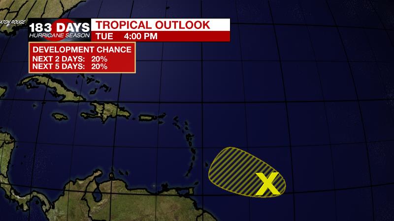
The Tropics: Showers and thunderstorms remain disorganized associated with the tropical wave located about 500 miles east of the Windward Islands. In addition, recent satellite-derived surface wind data indicate the wave has not become better defined since yesterday. This system is expected to move west-northwestward at 15 to 20 mph and has a limited amount of time remaining for development before upper-level winds become less favorable by Thursday.
Trending News
For the latest forecast and preparation reminders, visit the WBRZ Hurricane Center as we navigate all 183 Days of Hurricane Season.
The Explanation: Wednesday through Friday, a ridge of high pressure centered over the Midwest will nudge over the local area leading to a bit more subsidence (sinking air) and so showers and thunderstorms should taper into the isolated or widely scattered category with primarily afternoon activity. While widespread flooding issues are not expected, warm season storms are always capable of dropping a high total in a short time over a small area. Therefore, some localized issues could develop. Otherwise, beneath this ridge, high temperatures should reach climatological normal in the low 90s and some isolated mid 90s will be possible where showers and clouds are unable to keep thermometers in check. An inverted trough will move from east to west across the central Gulf Coast states over the weekend. At the same time, an upper level trough will dig into the Lower Midwest. These features will keep an unstable air mass over the area and will lead to an increase in areal coverage of showers and thunderstorms Saturday through Monday.
--Josh
The WBRZ Weather Team is here for you, on every platform. Your weather updates can be found on News 2, wbrz.com, and the WBRZ WX App on your Apple or Android device. Follow WBRZ Weather on Facebook and Twitter for even more weather updates while you are on the go.
More News
