

Latest Weather Blog
Wednesday morning video forecast
Related Story
Wednesday is expected to be the warmest of the week. A couple of cold fronts will bring cooler temperatures Thursday through the weekend, but also a threat for severe weather on Sunday.
THE FORECAST:
Today and Tonight: High temperatures will continue to increase through the 80s and approach the 90s on Wednesday. Reaching 87 degrees would be good enough to tie a Baton Rouge area record high, anything above would set a new mark. The chance for showers is lower, but not zero, and skies will be partly sunny. Overnight will be partly cloudy with low temperatures staying in the low 70s.
Up Next: A frontal system will then move into the region on Thursday. This will bring the potential for isolated showers by midday. Rain chances have turned markedly lower for this event over the last 24 hours. It looks as though most of the activity will occur behind the front, in the evening and at night. Clouds and showers may linger Friday morning followed by some returning sun and drier conditions through Saturday morning. Thermometers will turn cooler behind the first front. A reinforcing front may bring another round of showers and thunderstorms Saturday night through Sunday. Some of these could be strong and heavy. The Storm Prediction Center has already highlighted all of the local area in a threat for severe weather. Below average temperatures will persist through Tuesday.
The Mississippi River: At Baton Rouge, major flood stage continues with a level of 42’ as of Wednesday morning. Around April 11, the river is projected to crest near 43’. The high water is primarily an issue for river traffic and river islands, although some inundation will continue for a few spots north and south of Baton Rouge that are not protected by levees. Unprotected low-lying areas will be flooded and agricultural operations will be impacted on the west side of the river. The grounds of the older part of Louisiana State University's campus become soggy. This includes the area around the Veterinary Medicine building, the Veterinary Medicine Annex, the stadium and ball fields. The city of Baton Rouge and the main LSU campus are protected by levees at this level. This comes after a year where the gauge at Baton Rouge spent a record smashing run of 212 consecutive days above flood stage between January and August. Peaking at 44.1’ on March 19, 2019 the river set its 7th highest recorded crest at Baton Rouge. The level is also high in New Orleans and the U.S. Army Corps of Engineers has opened the Bonnet Carre Spillway.
THE EXPLANATION:
An upper level ridge of high pressure will persist over the region on Wednesday. Subsidence will lead to another mostly dry and almost hot afternoon. A strong cold front will dive south across the Eastern U.S. through Thursday. The front is likely to cross the I-10/12 corridor around midday Thursday with very little precipitation. Interestingly, the front may not be the main game with this system. A moderate to strong upper level disturbance will move over the cold front on Thursday evening and generate another round of rain and thunderstorms. Most of this activity will happen Thursday night. Beyond this front, a lull in precipitation will come early Friday through early Saturday as a deep upper level low pressure system in the Southwest U.S. moves over Texas.
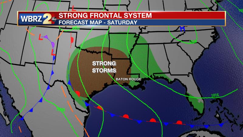
The upper level trough will begin to orient from northwest to southeast, this is called a negative tilt, and this if a reliable indicator for active weather. The trough will create a surface low pressure system and associated cold front that will move into the region on Sunday. At this time, forecast model guidance agrees on instability and wind shear being present to support severe weather. If moisture return from the Gulf of Mexico can occur beyond Thursday’s front and prior to this one, a widespread and significant severe weather event could be possible. Timing is not yet clear, but will come into focus as we get closer. The front will clear to the east by Sunday afternoon with cooler and drier conditions persisting into early next week. Please stay in touch.
Going to need attention to the @WBRZweather forecast heading into Sunday, @NWSSPC wording: "a substantial severe episode appears possible this weekend." #LaWX #MsWX pic.twitter.com/nOJrebRor1
— Josh Eachus (@DrJoshWX) April 8, 2020
--Josh
The WBRZ Weather Team is here for you, on every platform. Your weather updates can be found on News 2, wbrz.com, and the WBRZ WX App. on Apple and Android devices. Follow WBRZ Weather on Facebook and Twitter for even more weather updates while you are on the go.
News
