

Latest Weather Blog
Tuesday morning video forecast
Related Story
As the atmosphere warms and dries overhead, well above average high and low temperatures will continue. Many major cities from the Midwest to East Coast and all areas in between are expected to be above 80 degrees—much later in the year that usual. The best rain chances of the week are behind us.
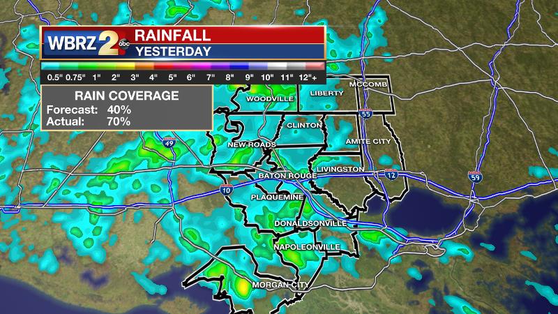
On Monday, a bit more rainfall occurred than expected. 70 percent of the forecast area received measurable rain and it lasted for several hours during the afternoon.
THE FORECAST:
Today and Tonight: Expect much more sunshine compared to previous days. With that, high temperatures will climb into the upper 80s and many weather stations should find 90 degrees. Humidity will create afternoon feels-like temperatures close to 100 degrees. If any showers are able to develop, most should be limited to the coast and highly isolated. Overnight will be mostly clear with lows near 73.
Up Next: An upper level ridge will maintain low rain chances and warm temperatures through the week. Highs will push 90 degrees, which is about 5 degrees above where we should be in the beginning of October. Low temperatures will also stay in the low 70s, which is about 10 degrees above normal.
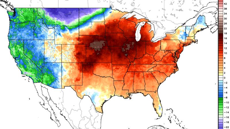
Warmth is enveloping much of the eastern two-thirds of the country with surface temperatures running 5 to 15 degrees above average. Dew points are forecast to stay elevated in the mid 70s allowing it to feel like temperatures are in the mid to upper 90s. By Saturday, the ridge will begin to weaken. This will cause temperatures top out in the mid to upper 80s, with rain chances increasing slightly. Looking beyond, there are no signs of significant cool air in the southeastern United States and the Climate Prediction Center maintains high probability for above average temperatures next week too.
The Tropics: Tropical Storm Leslie is positioned well east of Bermuda, but close enough to create large swells and high surf. With 65mph winds, the storm is moving slowly southwest but a turn to the north is forecast to occur late Wednesday into Thursday, followed by a motion toward the north-northeast on Friday. Leslie is forecast to become a hurricane by Wednesday morning, but will remain out to sea.
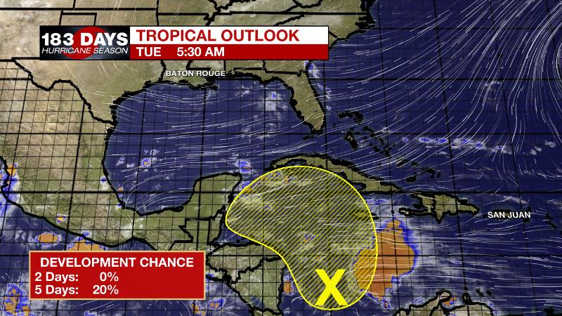
A broad area of low pressure has developed over the southwestern Caribbean Sea a couple hundred miles north of Panama. Shower and thunderstorm activity is limited, and unfavorable upper-level winds are expected to inhibit development over the next couple of days as the low drifts generally northward. By late week and over the weekend, upper-level winds are forecast to become a little more conducive for development when the system will be moving northwestward into the northwestern Caribbean Sea, and development chances have been put at 20 percent.
THE EXPLANATION:
Rain will become harder to come by each day into the middle of the week as temperatures move up another few degrees. After a very warm September, the southeastern U.S. will once again be dominated by a ridge of high pressure, centered over the local area by Tuesday.
Sept. 2018 was the 5th warmest on record. Data since 1930 @BTRairport; general multi-station "area" records for #BatonRouge back to 1893 make it 10th | #LaWX pic.twitter.com/zuKksXmSd0
— Josh Eachus (@DrJoshWX) October 1, 2018
With the ridge on top of the region, strong subsidence should lead to convection having a more difficult time developing and with that less cloud cover as well. Expect highs in the upper 80s to near 90 and it would not be surprising to see many locations reach as warm as 92. Records in the mid 90s should not be in danger, as deep easterly flow and abundant moisture in the low levels do not usually allow thermometers to maximize. Additionally, dew point temperatures in the 70s will keep it very humid and hold low temperatures about 10 degrees above average in the low 70s. There will still be abundant moisture and therefore with daytime heating, one or two showers are possible. Needing the sea breeze for lift, the best possibility for this will be near the coast. Further inland the ridge will keep convection down to a minimum. Rain chances may finally start to improve a little at the end of the week as the ridge begins to shift back to the northeast some.
--Dr. Josh
The WBRZ Weather Team is here for you, on every platform. Your weather updates can be found on News 2, wbrz.com, and the WBRZ WX App. on Apple and Android devices. Follow WBRZ Weather on Facebook and Twitter for even more weather updates while you are on the go.
News
