

Latest Weather Blog
Tuesday Morning video forecast
Related Story
The pop-up showers and thunderstorms will continue decreasing in number through mid-week. Signs point to a nice cool down coming over the weekend.
THE FORECAST:

Today and Tonight: Tuesday will bring less rain action than did Monday. Still, expect a partly sunny sky and thermometers in the know 80s to give way to a few showers and thunderstorms during the afternoon hours. Rain coverage in the 13 Parish, 3 County forecast area will be around 40 percent. Any showers should be short-lived but could briefly be heavy. Overnight, activity will taper with low temperatures in the mid 60s.
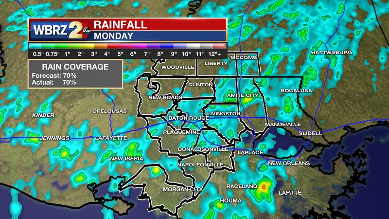
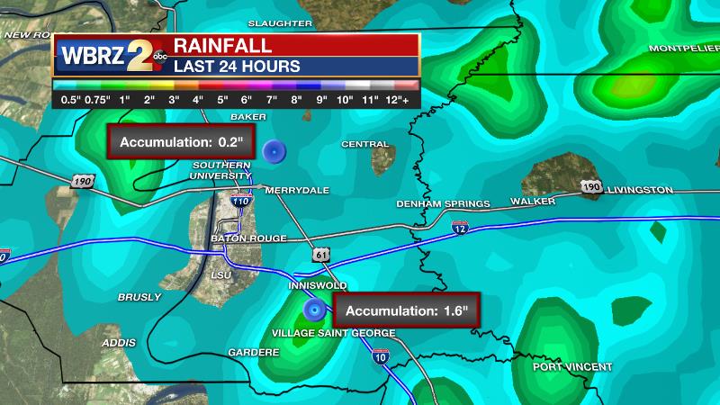
On Monday, the forecast verified nicely with approximately 70 percent of the WBRZ Weather forecast area receiving rain. As is typical with “pop-up” showers and thunderstorms, rainfall was very sporadic. In East Baton Rouge Parish alone, some neighborhoods missed out entirely while others picked up nearly two inches! Some localized street flooding was the result.
Wow, not sure why either vehicle tried to drive through that, but glad all are safe. #LaWX | CC @NWSNewOrleans @WBRZweather https://t.co/PvUNT7e40p
— Josh Eachus (@JoshEachus) April 17, 2017
Up Next: Even less rain action and more sun is anticipated for Wednesday. Thursday and Friday will be mainly dry, warm and humid with highs in the mid to upper 80s. Into the weekend a strong cold front is expected to pass through. This one will bring showers and thunderstorms but there does not appear to be a severe weather threat at this time. Then, as skies clear, humidity will break for a few days with temperatures 5-10 degrees below average Sunday into Monday.
THE SCIENCE: A weak upper trough continues to linger over the northwest Gulf of Mexico although the ripples of energy meandering through the flow are lessening. With this feature still in the region, a few showers and thunderstorms can still be expected on Tuesday but overall rain coverage in the forecast area should be much less than Monday. By Wednesday, the trough will be almost fully broken down with very little shower action expected. Thursday is a tricky forecast as forecast models are showing a ridge axis protruding from Mexico northeastward into the local area but they also hint at some positive vorticity advection around the ridge and associated precipitation output. For the reason, we will carry low end PoPs but do rain is not a good bet on this day. In addition, the presence of the ridge Thursday and Friday will result in warmer temperatures with continued humidity. Highs could easily reach the upper 80s in some spots. On Saturday, the jet stream will begin digging into the Southeast as a positively tilted trough takes shape. This trough will bring a strong cold front into the area but the orientation does not suggest a threat for severe weather at this time. A line of showers and thunderstorms is currently timed for Saturday Evening with considerably cooler air arriving by Sunday Afternoon. Readings could end up running 5-10 degrees below average Sunday and Sunday Night.
--Josh
News
