

Latest Weather Blog
Thursday morning video forecast
Related Story
Enjoy one more day of sunny, dry conditions. Humidity and rain chances will be creeping back up through Saturday.
THE FORECAST:
Today and Tonight: Thursday will be mostly sunny and a touch warmer with highs ticking just above average in the low 80s. Winds will be light and easterly. A clear night will follow, but lows will be up a touch compared to previous days, likely staying above 60 degrees.
If you have plans Sunday, stay in touch with the forecast. Rain may be on the way! #LaWX #MsWX pic.twitter.com/urgsVhO4az
— Josh Eachus (@JoshEachus) October 18, 2017
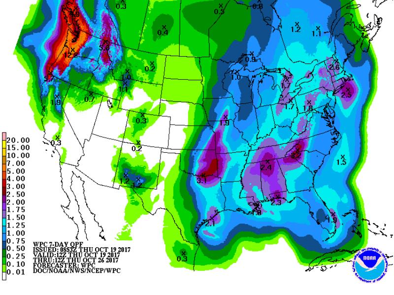
Up Next: Humidity will gradually return on Friday but it will not be nearly as sticky as last weekend. A slow moving cold front will put scattered showers and thunderstorms in the forecast for Saturday followed by widespread rain and storms for Sunday. Especially for the second half of the weekend, monitor the timing of rain, as some adjustments may be needed for outdoor plans. Neither severe weather nor flooding are expected, however a steady soaking rain is a possibility. At this time, a maximum of 1-2” of rain is possible over the weekend. The slow moving cold front responsible for these increased rain chances will trudge through on Monday leaving dry, more seasonable conditions for the days that follow. In fact, a more considerable cool down than what was felt earlier this week could occur behind that front by the middle of next week. It is possible that highs could struggle to leave the 60s on Wednesday.
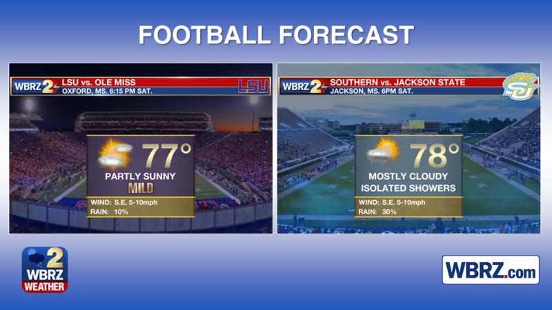
Both Baton Rouge area college football teams will be playing in Mississippi on Saturday evening. The LSU Tigers will be far enough north in Oxford that showers should not be an issue come kickoff time at 6:15pm. However, with Southern playing farther south in Jackson, some rain and thunder could dampen action in that 6pm start.
The Tropics: Alas, the tropics are all quiet. No development is expected over the next five days.
THE EXPLANATION:
Surface high pressure will settle in the Eastern U.S. through the end of the week resulting in easterly and eventually southeasterly winds by Friday. A weak upper level ridge will move across the area Thursday allowing temperatures to spike above average during the afternoon hours. The onshore flow kicking in on Friday will mean dew points begin to climb and some humidity will be felt in addition to slightly above average temperatures. While showers will not be possible beyond the coast, some clouds may develop over inland areas. An upper level trough will be digging into the Midwest and then Eastern U.S. Saturday into Sunday. There will be an associated cold front at the surface. The trough is going to be positively tilted meaning that the front will be rather slow to progress unlike its predecessor. Additionally, the positive tilt should keep the threat for severe weather at bay. With the front to the west on Saturday, showers and thunderstorms will be able to develop with some deeper moisture present. A lack of extensive forcing should mean only isolated activity is possible. By Sunday, positive vorticity on the eastern flank of the trough and extensive vertical lift due to the front should result in a large batch of rain and storms. Model precipitation totals are generally an inch or so as is the Weather Prediction Center forecast, and this seems fair with the mention of isolated higher amounts. We will still need to work out some timing details—whether much of the activity comes in a linear feature ahead of the front or an unorganized complex of showers. Given the orientation of the front and the trough, the latter seems more likely. While this leads to less intensity overall, it may expand the duration of light to moderate rain. That front will move through the area Monday, clearing out the inclement weather. A deepening trough in the East will lead to a reinforcing shot of cool air and at or below average temperatures through the middle of next week.
--Josh
The WBRZ Weather Team is here for you, on every platform. Your weather updates can be found on News 2, wbrz.com, and the WBRZ WX App. on Apple and Android devices. For new storm advisories as soon as they are issued at 1, 4, 7 and 10 am/pm follow WBRZ Weather on Facebook and Twitter.
News
