

Latest Weather Blog
WBRZ Forecast Area under TORNADO WATCH until 6pm Monday
The National Weather Service has issued a *TORNADO WATCH* for the WBRZ Weather forecast area until 6pm Monday.
Locations within the TORNADO WATCH area include the parishes of East Baton Rouge, Ascension, Assumption, East Feliciana, Iberville, Livingston, Pointe Coupee, St. Helena, St. Mary Tangipahoa, West Baton Rouge and West Feliciana in Louisiana and the Counties of Amite, Pike and Wilkinson in Mississippi.
Showers and thunderstorms will become more numerous through late morning until a line crosses the area later this afternoon. The main threats will include hail, gusty wind and possible a tornado.
A fast-moving storm system is racing from the Lower Midwest through the Gulf Coast. Ahead of this, pre-dawn showers and thunderstorms along the Gulf Coast have given way to sunshine and allowed destabilization of the atmosphere. Low-level moisture is ample with dew points climbing through the 60s. With modest upper-level wind support, conditions are favorable for severe thunderstorms.
Trending News
Showers and thunderstorms will rapidly end from west to east around dusk with clearing skies expected overnight.
Possible impacts: hail, damaging wind, one or two tornadoes
Timing: Until 6pm Monday; highest chances for severe storms Monday Afternoon
Actions: Be alert to rapid changes in weather, have access to bulletins through the WBRZ WX app., the WBRZ Cable Weather Channel, WBRZ Weather on Facebook and @WBRZweather on Twitter. With both the weather app. and Twitter, you can change your cellular phone settings to allow push notifications and alerts for updates from the WBRZ Weather team. Secure light, loose outdoor objects.
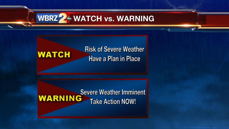
Remember: a watch means conditions are favorable for a specific hazard to develop in the future so you should have a readiness plan, a warning means a specific hazard is happening now and you need to take safety precautions immediately. The area is in a “slight” risk for severe weather—this means there is a higher chance than usual for strong thunderstorms.
A TORNADO WATCH means conditions are favorable for severe thunderstorms to produce tornadoes, winds of 58 mph or higher and/or hail 1 inch in diameter or larger, in addition to heavy rain and dangerous lightning. Those in and around the watch area should monitor weather information closely for possible warnings.
More News
