

Latest Weather Blog
Warming trend to follow seasons second freeze
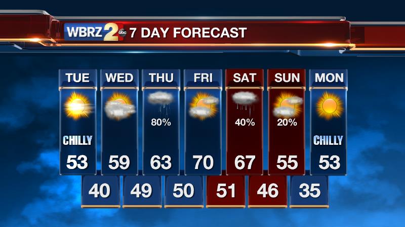
For just the second time this cool season, the Baton Rouge area dipped below freezing on Tuesday Morning. Last fall and winter, there were 17 freezes—five of those mornings slipped into the 20s.
Along with a warming trend, the weather will ease into an unsettled pattern over the next 48 hours.
THE FORECAST:
Today and Tonight: After a cold morning, sunshine will bring high temperatures back into the 50s. Some high clouds arriving later in the day may hold thermometers in the lower rather than middle 50s. Overnight, clouds will increase keeping temperatures warmer (though still chilly), right around 40°.
Trending News
Up Next: Clouds will continue to thicken on Wednesday with high temperatures in the upper 50s. Showers return to the region as early as Wednesday Night with rounds of rain likely on Thursday. Lows will be near 50 with highs near 60. Generally, an inch is expected area-wide. A break will occur on Friday with partial sunshine and highs in the upper 60s followed by more showers Saturday.
THE SCIENCE:
Forecast Discussion: High pressure continues to kick towards the East Coast. In doing so, winds are turning easterly with some moisture gradually building in at the surface. Temperatures will begin moderating as a result and will climb above average (low 60s/low 40s) by Friday. In the meantime, a shortwave trough in the Southwest U.S. will work toward the local area. As a result, clouds will build into the area on Wednesday in association with some positive vorticity advection. As moisture in the column increases and the shortwave trough axis pushes through, a period of showers is anticipated Wednesday Night through Thursday. After a short break in between upper level systems, a second wave will traverse the region on Saturday. This one will bring another round of showers. Behind the weekend wave, a strong surface high will settle into the Midwest transporting a much cooler air mass southward via northerly wind flow. Thus, cooler and drier conditions will prevail into the second week of January.
--Josh
Stay connected with me… share your thoughts!
Twitter: @Josh_Eachus
Google+: Josh Eachus
Facebook: Meteorologist Josh Eachus
More News
