

Latest Weather Blog
Many factors play into record warm winter
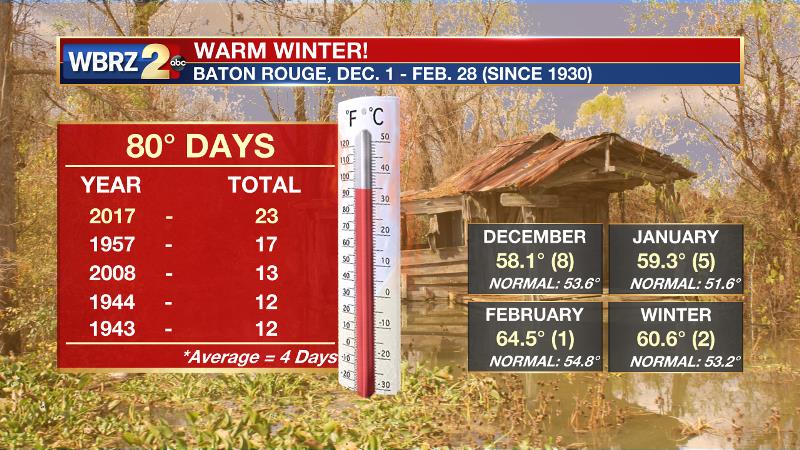
Baton Rouge - The Southeastern U.S. has wrapped up one of its warmest winters on record. For instance, since data collection began at Baton Rouge Metropolitan Airport in 1930, no winter has seen more days reach 80°F. There were 23 of them, normally there are four, and the previous record was 17 in 1957. The December through February average temperature of 60.6°F only fell just shy of the warmest winter on record, which occurred in 1932. It was the eighth warmest December, fifth warmest January and the warmest February.
Finally, to date, the last of six freezes this winter occurred on Jan. 8. If that stands, it will be the earliest, last freeze on record. Umm, yea, so what winter? Here is what is going on from a local to a national to a global perspective.
Records Abound!
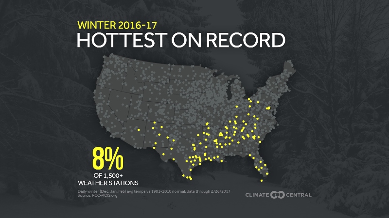
More than 120 weather stations, mostly in the Southeastern United States, notched their warmest winter on record, and 84 percent of over 1,500 stations recorded a warmer than average winter. Only the Pacific Northwest saw cooler than average temperatures.
Perhaps the most remarkable warmth came over the weekend of Feb. 11-12, when locations in Northern Texas, Western Kansas and Oklahoma, as well as Eastern Colorado set all-time February records for warmest temperatures. Beaver, Okla. hit 93°F on Feb. 11. The previous monthly record at that site was 90°F set on Feb. 28, 1904.
Wow! #February 2017 #record daily high to low count of 6045 to 112 = #ratio of 54 to 1 in U.S. through 2/26. #climatechange #globalwarming pic.twitter.com/CcOKHE5Jpr
— Guy Walton (@climateguyw) March 1, 2017Trending News
As Guy Walton has been pointing out on Twitter, record highs have been significantly outpacing record lows this winter. Remarkably, in February, there were 4,922 record highs and just 68 record lows (through Feb. 26). The numbers were not as drastic in December and January, but for the three month stretch, record highs outdid record lows by a 4:1 ratio.
What is the Cause?
This warm winter in the Southeastern United States is most likely part La Niña, part anomaly and part global warming. Let’s address each of the three individually.
La Niña
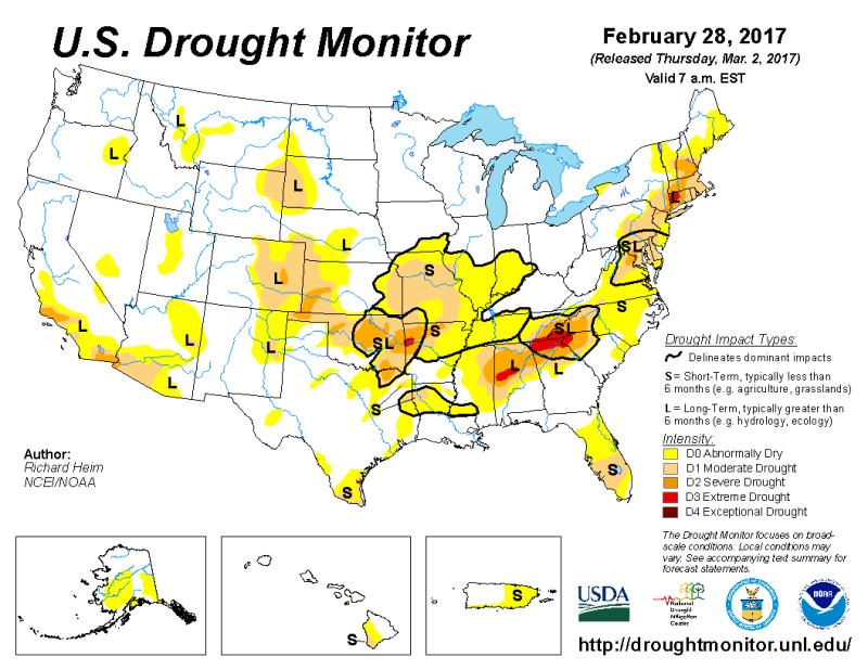
During the winter months, El Niño’s cooler counterpart in the Southwestern Pacific Ocean tends to cause warmer temperatures across the Southern Tier of the United States. A drier pattern is often noted as well, and though there are some exceptions like Baton Rouge, drought is showing up across a large part of the region. For the Southeastern and Southern Climate Regions, 61 percent and 49 percent of the areas are in drought, respectively.
Anomaly
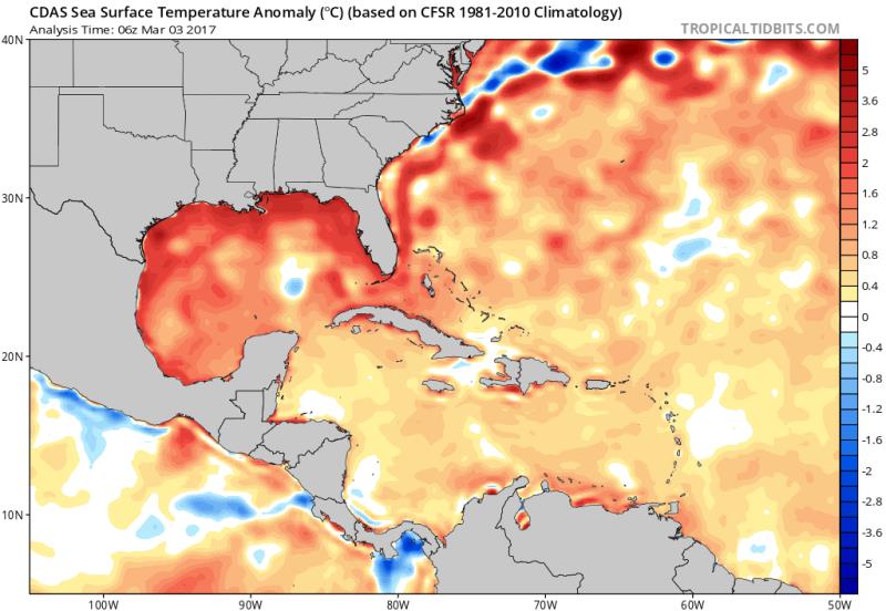
Look, weather records happen. Weather is entropic and out of the ordinary patterns are to be expected from time to time. It is for that same reason that amidst some of the planet’s warmest years, record lows are still happening, albeit in much lower numbers than record highs. One anomaly factoring into the record warmth this winter (which may have larger ties) is an unusually warm Gulf of Mexico. Sea surface temperature anomalies are 2-5°C above normal.
As areas of high pressure set up behind cold fronts along the East Coast of the United States, warm southerly breezes have been transporting warmer, maritime air poleward. Not only is this boosting winter temperatures more than usual, but it could have dire ramifications when continental polar air masses dive southward early in the spring season.
2017 continues to be the warmest on record for the Gulf of Mexico. Surely not a good sign going into severe season. pic.twitter.com/LRqM8zdtYv
— Michael Lowry (@MichaelRLowry) February 28, 2017
Global Warming
It is too soon to say that this warm winter was because of global warming. Attribution studies conducted by climate scientists evaluate the probability of extreme weather events both with and without the effects of global warming.
While we may soon find out that this warm winter was made more likely by global warming, we cannot say if it was a direct result. For instance, by changing from a six-sided to a four-sided dice, you increase your chances of rolling a one, but that doesn’t mean you will roll a one. See what I’m getting at here? Increased probabilities…
But, to jump the attribution studies, there is a larger trend underway. With data back to 1895, the United States is in the midst of its warmest five, three, two and one year periods on record, coincident with the highest levels of carbon dioxide in earth’s history. Climate scientists have linked carbon dioxide, a greenhouse gas, to earth’s temperatures. Due to this, at least in the last 126 years of temperature records, the Lower 48 is in uncharted warm territory.
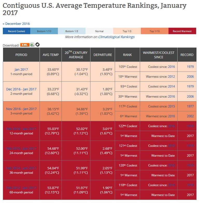
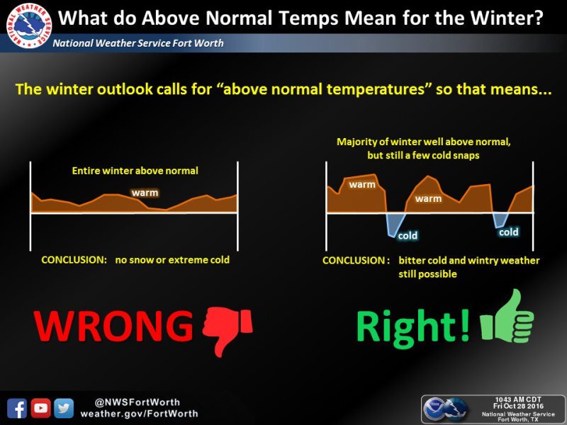
So if global warming may have been at play, why did it still get cold sometimes? The answer is simple, weather is not climate. The National Weather Service Fort Worth explains a pattern of above normal temperatures. While there may be some spells of cold “weather” the “climate” will average out to be warmer over a longer period.
Even as it is still cool in northern locations, many cities like Philadelphia and Minneapolis are registering consecutive months with above average temperatures. As Glenn Schwartz points out, there comes a point, like a 0.4 percent chance, where coincidence becomes less likely.
Will the Warmth Continue?
It sure seems that way. Any way you look it, from the Climate Prediction Center Outlook through May, to the ongoing warm anomalies in land and sea surface temperatures, much of the United States is likely to find above average temperatures in the coming months.
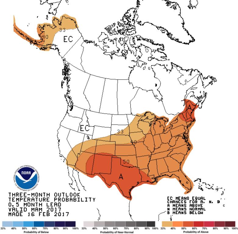
The La Niña is over; meaning waters are again warming in the Western Pacific Ocean. There is uncertainty as to whether or not an El Niño will soon develop, but with the large scale climate driver seemingly at bay for now, there is no reason to believe that 2017 won’t be the 35th consecutive year with above average global land temperatures.
This blog also appeared on wxshift.com. For more information, questions and feedback, you can email Meteorologist Josh Eachus at jeachus@wbrz.com or reach out on Facebook and Twitter.
More News
