

Latest Weather Blog
Tropical System Set to Form in the Gulf
THE FORECAST:
Tonight and Tomorrow: Spotty showers and storms will be tapering off until 10 PM, with clouds breaking shortly after and through the overnight period. Temperatures will be dropping to an overnight low of 72°, with light winds out of the east. The approaching frontal system from the northwest that helped to supply afternoon storms Saturday, will push further north to bring more isolated and spotty showers and storms through the afternoon on Sunday. Temperatures will still be just shy of 90°, as easterly winds between 5 and 10 mph help to keep dew points in the low to mid 70s.

Up Next: Similar conditions of isolated showers and highs in the upper 80s will stay into Monday, but the weather pattern changes quite drastically as we head into the midweek. An approaching cold front and tropical system will increase rain chances and eventually bring cooler conditions as we proceed into the weekend.

The Tropics
Trending News
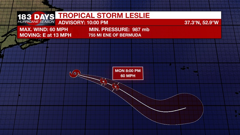
Tropical Storm Leslie still the only named storm in the Atlantic, but that could change shortly. Currently, Leslie is located about 755 miles east-northeast of Bermuda, with 60 mph sustained winds, and moving east at 13 mph. A faster motion toward the east and east-southeast is expected through the middle of next week, taking Leslie across the central and eastern Atlantic. Some fluctuations in intensity are expected during the next 2 to 3 days.

We are also keeping our eyes on two separate waves in the Atlantic, but one is likely to form into a tropical depression within the next 24 hours. This wave is already delineated as Potential Tropical Cyclone Fourteen, and is located about 120 miles south of Cozumel, Mexico, and 240 miles south-southwest of the western tip of Cuba. This current system has 30 mph sustained winds, and is moving north at 7 mph. This general motion is expected for the next couple of days. On the forecast track, the low or tropical cyclone should move near the eastern coast of the Yucatan Peninsula tonight through Sunday night, and then move into the southern Gulf of Mexico on Monday. Strengthening is forecast during the next couple of days, and the system is expected to become a tropical depression later tonight or on Sunday and a tropical storm on Sunday night. A reconnaissance plane will be investigating the system on Sunday. The National Hurricane Center is forecasting a high probability of tropical development at 100%.
*Current Tropical Storm Warnings are in effect for:
-The Cuban provinces of Pinar del Rio and the Isle of Youth
*Current Tropical Storm Watches are in effect for:
-The coast of Mexico from Tulum to Cabo Catoche
The second wave is a non-tropical low pressure system, located about midway between the Azores and the Canary Islands. This system is producing a large area of disorganized showers and thunderstorms, along with winds to near gale force mainly north of the center. The low could gradually acquire subtropical or tropical characteristics over the next few days while the system moves generally eastward and remains over warm waters. By Wednesday, however, environmental conditions are expected to become unfavorable for any significant development to occur. The National Hurricane Center is forecasting a 20% chance of tropical development within the next 2 days, increasing to 30% chance within the next 5 days.
THE EXPLANATION:
The low pressure center over Oklahoma that helped to provide scattered showers on Saturday, will travel north along the frontal boundary into Illinois on Sunday. This will allow for shower activity to decrease and stay isolated Sunday and into Monday. Temperatures will still stay in the upper 80s, as the upper-level ridge over the southeast will keep warm, gulf air moving inland through the start of the week. A tropical system will develop in the Gulf, and strong cold front will also develop to our west. This will be the first cold front that will stay together and push into the Gulf, and it is just in time! The tropical system will approach the Gulf Coast just as the cold front pushes in to approach the Gulf on Tuesday. Scattered showers and storms will dominate the weather pattern during this period until Wednesday. The frontal system will help to push the tropical system east, likely making landfall along the Florida Panhandle late Tuesday into early Wednesday. Not only will we be dodging another tropical system, but the cold front will bring with it cooler and drier conditions by Thursday. High temperatures will drop into the low 80s on Friday, with lows potentially dipping into the upper 50s Thursday night. Even though Hurricane Season ends November 30th, it becomes rare for a system to push into the Central and West Gulf Coast after the first intact cold front of the fall. What a way to end the season!
--Meteorologist Matt Callihan
The WBRZ Weather Team is here for you, on every platform. Your weather updates can be found on News 2, and the WBRZ WX App. on Apple and Android devices. Follow WBRZ Weather on Facebook and Twitter for even more weather updates while you are on the go.
More News
