

Latest Weather Blog
Surprise Tornado Friday: what happened?
BATON ROUGE - On Friday, an EF-1 tornado briefly touched down in East Baton Rouge Parish near Old Hammond Highway. Video confirmed the twister and damage photos verify what was surely a terrifying stretch of seconds for those nearby.
Misused media phrase: "It came without warning." Usually, there IS one that was not received. Today in #BatonRouge, there was no warning ??.
— Josh Eachus (@JoshEachus) May 12, 2017
Unfortunately, those nearby did not receive a notification from their WBRZ WX App. or a NOAA Weather Radio, because for that particular storm, there was no warning and no sign of a tornado. Until one actually forms and is spotted or reported, on-duty meteorologists can only warn for tornadoes based on what Doppler radar is displaying.
A textbook tornadic signature on radar will feature a well-defined “hook appendage” on the southern end of the storm cell with a storm motions showing wind moving toward and away from the radar at the same time, indicating rotation.
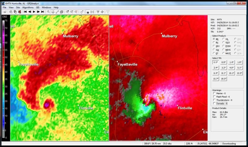
Textbook supercell tornado appearance on Doppler radar: LEFT = hook appendage, RIGHT = storm motions toward and away from radar | Via NWS Huntsville, Alabama
Today, there was no such appearance on radar. Being detected an approximately 9:01am was a cluster of non-severe showers and thunderstorms that may have been producing wind gusts over 30mph and heavy rain. What actually occurred was much different.
Trending News
Video of a possible tornado touchdown in the Coursey Blvd. area of Baton Rouge. #lawx (Video via Jacob Gunter) pic.twitter.com/toRfkYzXZF
— WBRZ News (@WBRZ) May 12, 2017
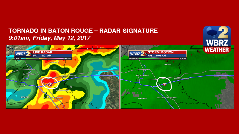
Tornado appearance on Doppler radar, Friday, May 12, 2017. LEFT = NO hook appendage, RIGHT = NO storm motions toward and away from radar | Via WBRZ Weather
Of course there are times when the radar detects something in between the textbook appearance and the non-appearance observed today, but that still provides enough information for a warning to be issued.
Even coming into the day, there was no suspicion that a tornado would form. Again, by textbook, the ingredients simply were not in place. Twice daily, weather balloons sample the atmosphere and numerical values are assigned to several parameters used to determine the possibility of severe weather. Instability was only marginal, and spin in the atmosphere was well below the typical minimum threshold needed for tornadoes to form. As such, the National Weather Service Storm Prediction Center issued a 1/5 “marginal risk” for severe weather, expecting possibly one or two storms to produce gusty wind or hail. Today was further proof that we all should take each and every severe weather risk seriously, and map out our severe weather plan for any situation, before a storm threatens.
|
Ingredient |
Usual Bottom Threshold |
Today’s Value |
|
Instability |
1,000 |
986 |
|
Spin |
150 |
116 |
With all of this in mind, one question may remain. Why was no warning issued even after video clearly showed a tornado touchdown? Simply put, it had weakened and lifted just as quickly as it dropped. Situations, such as this, likely happen an immeasurable number of times throughout the year. Around the United States, there are brief spin-ups occurring in rural areas or open fields where tornadoes can easily hide. In a populated area like the city of Baton Rouge, no matter how brief or small, there simply is nowhere for a tornado to hide.
There was also damage in White Castle, where a warning had been issued. However this is not yet a confirmed tornado. The National Weather Service will send storm survey crews to each location identify the strength of the storms and assign ratings where necessary. Fortunately, as of this writing, despite the missed warning, no fatalities have been reported.
More News
