

Latest Weather Blog
Summer's first big sizzle
Shade and hydration will be important over the next few days. The heat and humidity combo will cause the body to sense temperatures over 100° today, tomorrow and Friday afternoons. Don’t look for relief overnight, lows will barely drop beneath 80°.
THE FORECAST:
Today and Tonight: On Wednesday, the area will begin to transition. Afternoon shower and thunderstorm coverage will become more isolated in nature. Only expect one or two “pop-ups” in the peak heat of the day resulting in about 30% coverage in the 13 Parish, 3 County forecast area. With partly sunny skies otherwise, high temperatures will climb into the low 90s as humidity remains oppressive. Overnight lows will be in the mid 70s beneath mostly clear skies.
Up Next: Mostly sunny skies will rule on Thursday and Friday. High temperatures will respond to more dry times and sunshine by charging into the mid 90s. The stickiness won’t go anywhere—afternoon humidity will stay up and this combination will lead to the highest and most prolonged heat of the season thus far. Expect heat indices or “feels like” temperatures to be in the low 100s from late morning into the afternoon. The humidity, created by high dew points, means that overnight as lows won’t be able to slip out of the mid 70s. A "backdoor" cold front may move, strangely, from northeast to southwest through the region this weekend which would bust up some of the humidity.
Trending News
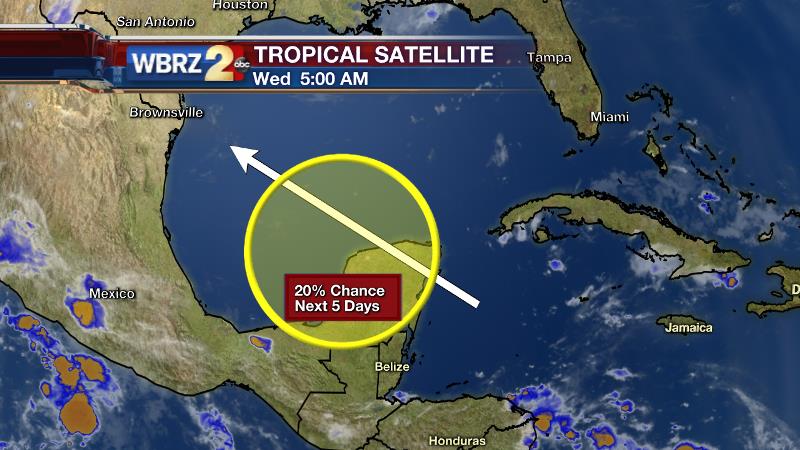
The Tropics: A broad area of low pressure may gradually come together near the Yucatan Peninsula over the next 5 days. The National Hurricane Center gives the region a 20% of development as warmer waters and favorable upper level conditions come into play. However, at this time, steering winds would continue pushing this system northwest from there and away from Louisiana.
THE SCIENCE:
Forecast Discussion: A very broad ridge will overtake the Southern United States for the reminder of the week. The Gulf Coast will notice peripheral effect from this ridge with a slow drying trend in the upper levels and a developing cap. This will begin to lid the atmosphere somewhat causing diurnal showers and thunderstorms to back off. Enough warmth and humidity will linger to pop an isolated shower or storm on Wednesday but much of Thursday and Friday should be dry, except for possibly coastal areas. With additional sunshine, solar radiation will be maximized and with dew points in the mid to upper 70s, afternoon heat indices or “feels like” temperatures will feel like the low 100s.Don’t be surprised if a heat advisory is issued. Into Saturday, a deep trough pushing southward into the Southeastern United States will steer a backdoor cold front toward the local area. With this system, we can expect a few more showers and thunderstorms. The National Weather Service is hinting at the potential for some severe weather. This would be somewhat of a rare scenario, not only that it could be a summer cold front, but a northeast to southwest moving cold front—so we’ll keep an eye on this. On the other side, a noticeable difference in humidity is expected.
--Josh
For updates, stay connected with Meteorologist Josh Eachus:
More News
