

Latest Weather Blog
UPDATE: dangerous travel possible tonight
With rain in around Baton Rouge, frozen precipitation north of the city and freezing temperatures expected tonight -- icy roads and bridges will be a concern tonight. See an updated forecast, detailed timing for your parish or county and how to prepare for the wintry weather in our full breakdown below.
A *WINTER WEATHER ADVISORY* has been issued for East Baton Rouge, West Baton Rouge, Iberville, Livingston, Pointe Coupee, West Feliciana, East Feliciana, St. Helena and Northern Tangipahoa Parishes until 12am Saturday. This means wintry precipitation could cause slick road surface and you should use caution if driving is necessary.
A *WINTER STORM WARNING* has been issued for Wilkinson, Amite and Pike Counties until 12am Saturday. This means wintry precipitation is expected to accumulate and cause dangerous conditions on roadways. Travel should be avoided.
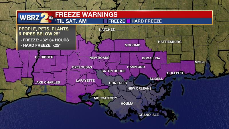
A *FREEZE WARNING* has been issued for Iberville, Ascension, Assumption and St. James Parishes from 12am – 11am Saturday. This means sensitive plants could be killed due to cold. Ensure people and pets have access to warm shelter.
A *HARD FREEZE WARNING* has been issued for East Baton Rouge, West Baton Rouge, Livingston, Pointe Coupee, West Feliciana, East Feliciana, St. Helena and Tangipahoa Parishes as well as Wilkinson, Amite and Pike Counties from 12am – 11am Saturday. This means, in addition to the freeze warning criteria, temperatures could reach 25 degrees or lower for several hours. As a precaution, exposed outdoor pipes should be wrapped.
A *WIND CHILL ADVISORY* has been issued for the entire WBRZ Weather forecast area until 10am Saturday. This means the "feels like" temperature could be at 13 degrees or lower for a few hours. Minimize time outdoors if possible.
Trending News
THE FORECAST:
Today and Tonight: As clouds and pockets of rain persist on Friday, cold air advancing from the north will guide thermometers down through the day. Temperatures will fall into the 30s by late afternoon—low 30s north of Baton Rouge, mid 30s in the city and upper 30s south of I-10. Rain will begin to mix with frozen precipitation from northwest to southeast during the afternoon and evening hours.
Precipitation (medium confidence):
Rain only: Ascension, Assumption, St. James, St. Mary Parishes
Rain and sleet: East Baton Rouge, Iberville, Livingston, West Baton Rouge Parishes
Rain, sleet and possibly freezing rain: East Feliciana, St. Helena, Tangipahoa Parishes
Rain, sleet, freezing rain and possibly snow: Pointe Coupee, West Feliciana Parishes and Amite, Pike, Wilkinson Counties
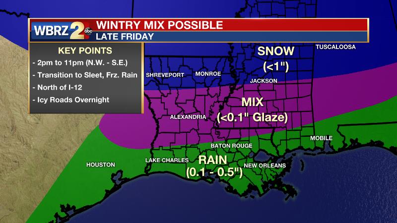
Estimated Timeline (medium confidence):
Pointe Coupee, West Feliciana Parishes and Amite, Pike, Wilkinson Counties:
10am – rain mixing with sleet
12pm – full transition to sleet, freezing rain
2pm – snow may mix in
10pm – precipitation ends
East Feliciana, St. Helena, Tangipahoa Parishes:
12pm – rain mixing with sleet
4pm – full transition to sleet, freezing rain
11pm – precipitation ends
East Baton Rouge, Iberville, Livingston, West Baton Rouge Parishes:
4pm – rain mixing with sleet
11pm – precipitation ends
Ascension, Assumption, St. James, St. Mary Parishes:
12am – rain ends
Impacts (medium confidence): In the event of an extended period of freezing rain near and north of the Louisiana/Mississippi border, a light glaze of ice, up to an eighth of an inch, could coat trees and power lines. However, this would not be thick enough to down branches or knock out power. In addition, any coating of freezing rain could make driving hazardous. With temperatures quickly falling below freezing tonight, there will not be enough time for surface moisture to evaporate. Therefore roads and bridges could develop ice as far south as the I-12 corridor during. "Black ice" is a concern on less traveled streets where water rapidly freezes and appears wet, but is actually frozen. Any thin ice will melt as the sun returns on Saturday Morning.
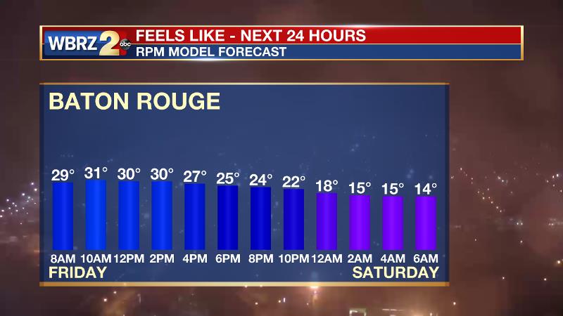
Cold temperatures will make it dangerous for people and pets to be outdoors for even a short time. Northerly winds of 10mph will make air temperatures in the 20s feel like the teens at times. In addition, where air temperatures drop below 25 degrees for an extended time, exposed, outdoor pipes could burst.
Actions: Monitor the forecast. Stick with the WBRZ Weather Team on Facebook and Twitter and catch forecast on WBRZ News 2 for updates through the day.
If frozen precipitation occurs or ice develops on road surfaces, have “stay at home” plans for tonight and early tomorrow morning as driving could become dangerous. Make sure that people and pets have access to warm shelter.
Wrap exposed, outdoor pipes as a precaution. For areas south of I-10 experiencing the first freeze of the season, protect sensitive plants.
THE SCIENCE:
Weather Discussion: an area of low pressure will move northeastward through the Gulf of Mexico while a very cold air mass advances into the region. A front associated with the surface low pressure system will cause overrunning precipitation through Friday. As cold air wedges in at the surface, a transition from rain to sleet and freezing rain is expected to occur Friday Afternoon. Exactly where the cutoff between liquid and frozen precipitation occurs will be very difficult to determine, but here is the latest thinking:
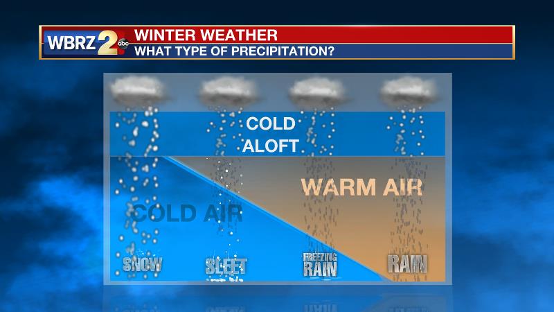
In examining a vertical profile of the atmosphere, a warm layer in the lower levels exceeding 3 degrees Celsius will initially exist. Such a warm layer means complete melting of any ice or snow falling through the atmosphere will occur. Below that, will be another freezing layer possibly deep enough for liquid to refreeze into sleet pellets. The ground temperature will be very close to freezing. The warm layer is expected to cool from northwest to southeast through the event. As this occurs, rain will begin to transition to mix with sleet in the same direction. Once surface temperatures slip to or below 32 degrees, freezing rain will begin to glaze surfaces. If the low-level warm layer erodes entirely, some snow may be observed.
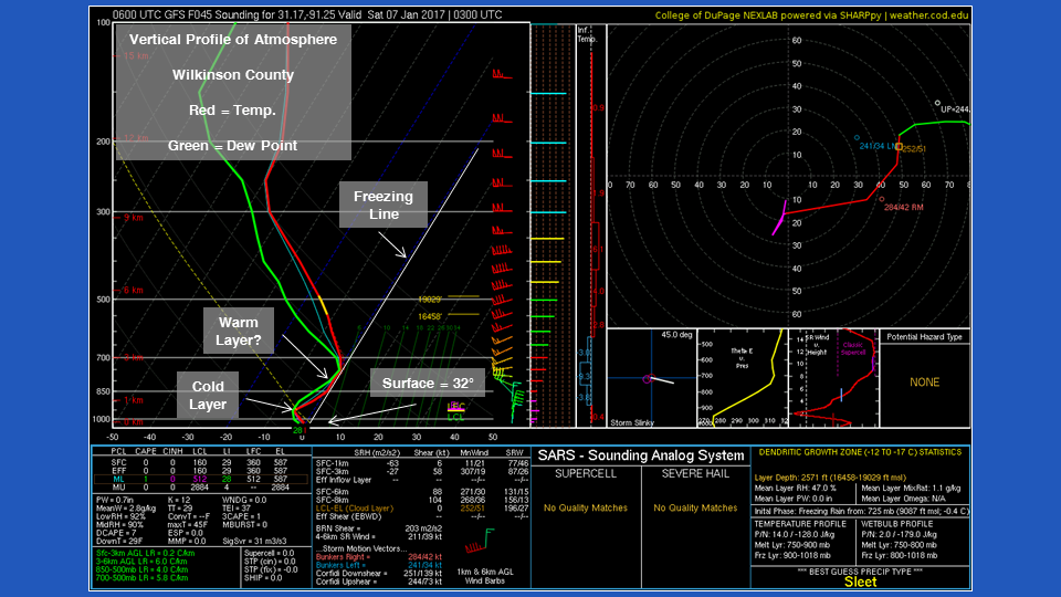
Full erosion of the low-level warm layer is expected to occur for locations north of a line between New Roads and Kentwood and surface temperatures will be below freezing. As such, rain will begin to mix with sleet as early as Friday Afternoon and become a combination of light freezing rain, sleet and possibly snow before ending Friday Night. With temperatures remaining below freezing Friday Night, roads and bridges could become icy.
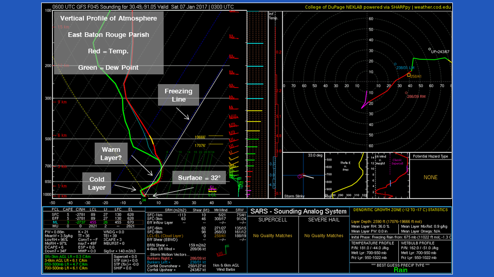
For Baton Rouge and areas along the I-12 corridor, the atmosphere is forecast to have a much tougher low level warm layer. A shallow cold pocket above the surface will allow some refreezing and sleet to mix with rain. A full transition is unlikely before the precipitation ends. However, with the surface temperature dropping below freezing Friday Night, some icy spots may still occur.
For areas south of Baton Rouge, the warm layer will be too thick and surface temperatures will stay above freezing until Saturday Morning. Therefore, only rain is expected and no icy spots are anticipated.
More News
