

Latest Weather Blog
Outdoor plans look good again
On Thursday, Baton Rouge Metropolitan Airport reached 91° at 2:47pm. This marked the first 90°+ day in 2016 and the first since October 16, 2015.
THE FORECAST:
Today and Tonight: Friday will begin with a few lingering showers near the coast. A weak cold front will continue to fizzle over the area through the day clearing clouds from north to south. Afternoon sun will return bringing highs back into the mid 80s with noticeably less humidity. Overnight skies will go all clear with lows in the low 60s.
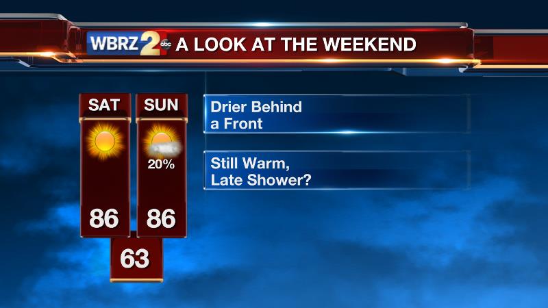
Up Next: Saturday will feature mostly sunny skies with a high in the mid 80s. Humidity will remain lower than it was during the week. The nighttime hours will stay mainly clear with a low in the mid 60s. By Sunday Afternoon, a few clouds will return and there is an outside shot at an isolated shower—especially for areas north and west of Baton Rouge.
Trending News
THE SCIENCE:
Forecast Discussion: A dissipating cold front will continue slipping southward into the Gulf of Mexico through Friday. The exiting front and arrival of a surface high pressure system dropping in from Arkansas will promote a north south clearing trend. Sunshine is expected by afternoon. With a drier column of air moving into the region there should be a brief respite in humidity but larger diurnal range in temperatures. Saturday will begin near average, in the low 60s, with highs reaching for the upper 80s. A weak impulse sliding through the subtropical jet stream may try to develop an isolated shower or thunderstorm as early as Sunday but it looks as though most of the available energy will not arrive until Monday. We’ll keep an eye on this in case it has an effect on some Late Sunday outdoor plans. Forecast models are not in good agreement as to how next week will unfold. While both the GFS and ECMWF suggest some positive vorticity advection on Monday, the ECMWF has a much stronger shortwave and thus much more rain coverage—with the possibility of s few stronger storms. At this time, we’re blending the two solutions. For Tuesday, both models depict a break between systems followed by another wave on Wednesday. IN this case, there is agreement among rain and thunderstorms; however the ECMWF is MUCH wetter with an inch or two of rain being indicated. Needless to say, stick with us as the details for next week become clearer.
--Josh
For updates, stay connected with Meteorologist Josh Eachus:
More News
