

Latest Weather Blog
No surprise ending, year to wrap up warmer
Fall forecasts were right on in projecting a warm, dry north and wet south for the fall months. As the United States transitions into winter, 2015 figures to wrap up with much of the same.
In Southeastern Louisiana, an El Niño controlled pattern has produced one of the wettest fall seasons on record with very few bouts of cold air. The National Oceanic and Atmospheric Administration’s Climate Prediction Center has released a December temperature and precipitation outlook that suggests recent trends will continue.
According to the CPC, there is a 30% likelihood that the next four weeks will bring above average temperatures to the Baton Rouge area. The WBRZ Weather team has examined the global forecast models, that are capable of offering guidance through mid-month, and does not see any evidence of potent or extended cold spells.

Trending News
The northern tier of the United States has an even higher likelihood of checking out of the year with above average temperatures. In the Great Lakes and Northeast regions, a 70% probability of warmer than normal is all but a certainty. Ensemble forecast models project surface temperatures to be 5-10° above average—even higher than that in Canada. That is not to say “warm” weather is expected, even well above average still leaves high temperatures in the 30s and 40s.

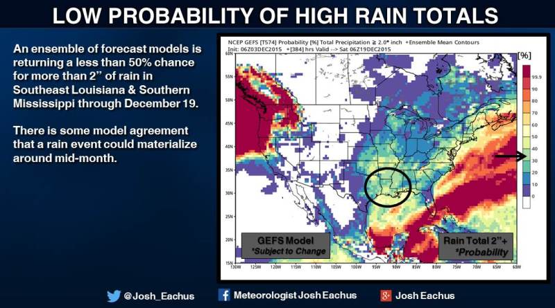
The CPC indicates that the staple of a Southern U.S. El Niño will pour on—with more episodes of rain. The Baton Rouge area is given a 40% chance of above average precipitation for December which is historically about 5.5”. Amounts from the first two days have already contributed about 0.4” of that. The WBRZ Weather Team does not believe this portion of the outlook will verify though. Only one rain chance is shown on the models through mid-month. Furthermore, with a model ensemble depicting a less than 50% chance for 2” of total rain through December 19, it would take a remarkable event to surpass average.
Around the remainder of the country, South Florida, the North Carolina Piedmont and the Pacific Northwest are all looking wetter than average. The Upper Rocky Mountain West is the only region given a prediction of below average precipitation.
Forecasts that extend beyond one week are based off of trends and large-scale patterns. Certainly, there could be the odd dry spell in the south or a polar air mass in the northeast—but overall, the weather often balances out to numbers reflected in the long-range predictions.
Above average temperatures in North America to end 2015 come at the tail end of what has been the hottest year on record around the globe. With this record-setting El Niño in full-swing, there is no precedent as to what may be expected in the winter months of January and February other than an exaggeration of the trends already occurring.

Chat with Meteorologist Josh Eachus on social media:
More News
