

Latest Weather Blog
Nate strengthening, main impacts to stay east of Baton Rouge Metro
Summary: As of 10am Saturday, Hurricane Nate was located 265 miles south of Biloxi, Mississippi with a minimum central pressure of 984mb and maximum sustained winds of 90mph and was moving north, northwest at 26mph. Landfall is projected near the mouth of the river then east of the Louisiana state line along the Mississippi Gulf Coast Saturday evening. Nate could strengthen some as it moves toward landfall, with winds possibly increasing up to 105mph. In coastal Louisiana, Mississippi and Alabama, storm surge could be a significant threat, possibly up to 11 feet.
WATCH LIVE FORECAST UPDATE HERE
The following information is for the WBRZ Weather forecast area including Ascension, Assumption, East Baton Rouge, West Baton Rouge, Pointe Coupee, Iberville, Livingston, East Feliciana, West Feliciana, St. Helena, St. James, St. Mary and Tangipahoa Parishes as well as Amite, Pike and Wilkinson Counties. If you need information outside of these areas, visit the National Weather Service. If you would like to view the detailed hurricane local statement, CLICK HERE.

In the Baton Rouge area, scattered showers and thunderstorms can be expected through early Sunday morning. Brief downpours will be possible. It will be breezy, but high winds are not anticipated. Impact to the Baton Rouge area from Hurricane Nate is expected to be minimal with the exception of Gulf and lake shorelines where there is a threat for storm surge. See below for a full description of potential impacts. Conditions will improve quickly on Sunday. Showers will end and some breaks of sunshine will be possible.
Trending News
Alerts: A *TROPICAL STORM WARNING* has been issued for parts of the WBRZ Weather forecast area including northern Tangipahoa, Livingston, Ascension, Assumption and St. James Parishes. Where more significant storm surge is expected, a *HURRICANE WARNING* has been issued for southern Tangipahoa Parish south and east through New Orleans to coast.
Impact: Given the current forecast, tropical storm conditions will be possible in southeast Louisiana, with hurricane conditions possible near the immediate coast. At this time, impact to the Baton Rouge Metro area are expected to be minimal.

SURGE: High water will continue on shorelines and The National Weather Service has issued a *STORM SURGE WARNING* until Sunday evening due to this threat. Water levels could reach 1 to 3 feet above ground on the shore of Lake Maurepas, 3 to 5 feet above ground on the shore of Lake Pontchartrain, 4 to 6 feet above ground from Morgan City to the mouth of the Mississippi River and 7 to 11 feet above ground from the mouth of the Mississippi River eastward to the Mississippi/Alabama border.
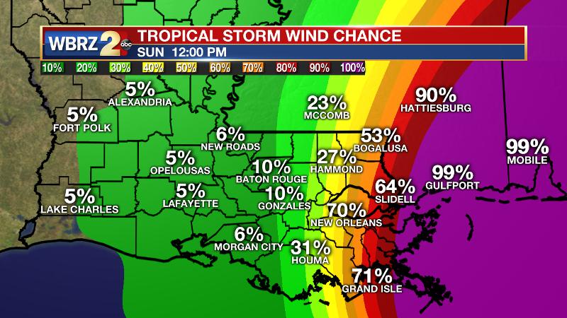
WIND: The chance for tropical storm force winds is minimal in the WBRZ Weather forecast area, with a 30 percent chance of winds over 39mph in Hammond down to less than 10 percent chance for Baton Rouge and points to the west. New Orleans and areas east have a greater than 70 percent chance of winds over 39mph.
RAIN: Nate will be a fast mover. Therefore, 1 to 3 inches, and possibly less, appears to be possible over the weekend with the lowest amounts near the Atchafalaya Basin and isolated higher amounts eastward toward Mississippi. Additionally, the threat for tornadoes should be lower in the Baton Rouge area than states east.
Actions: As a rule, it is always good to prepare for one category higher than what is forecast. In this case, since a category one storm is expected, prepare for a category two storm in the event of last minute strengthening. Those with coastal interests should finalize necessary precautions by Saturday morning. On shorelines, expect inundation and move belongings to higher areas as possible. Listen to evacuation orders if issued, and leave by Saturday morning as roads may become impassable thereafter. Inland, secure loose objects outside, as they could become fly around in strong wind. Prepare for possible power outages. Be sure to have a week’s worth of drinking water, non-perishable food, pet food, propane for grilling and extra battery power for flashlights and mobile devices.
For a full rundown of hurricane readiness including evaluating risk in your area, gathering supplies, checking insurance and prepping your home, CLICK HERE. The WBRZ Weather Team is here for you, on every platform. Your weather updates can be found on News 2, wbrz.com, and the WBRZ WX App. on Apple and Android devices. For new storm advisories as soon as they are issued at 1, 4, 7 and 10 am/pm follow WBRZ Weather on Facebook and Twitter.
More News
