

Latest Weather Blog
More downpours during the days ahead
More widespread showers and thunderstorms are expected this weekend. Like Monday and Wednesday, any storms could produce downpours leading to some localized flooding.
THE FORECAST:
Today and Tonight: Rain coverage will remain the scattered status quo on Thursday. Partly sunny skies will give way to scattered showers and thunderstorms forming after a high temperature near 93 degrees. Most of the activity will form due to marine breezes and then interactions with outflow from decaying thunderstorms. In other words, formation and location of storms will be erratic. Overnight low temperatures will drop into the mid 70s.
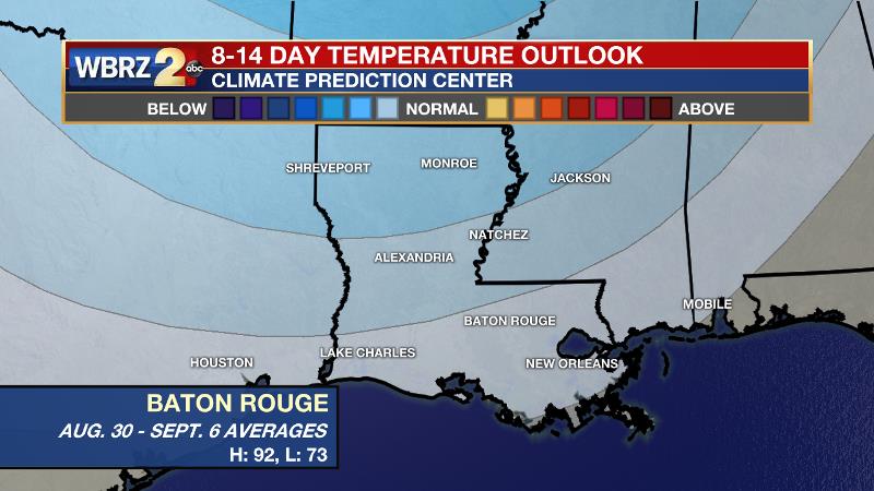
Up Next: By Friday, a weak disturbance in the Gulf of Mexico will allow a plume of tropical moisture to move overhead and enhance rain coverage. Though many areas will experience rain Friday through Sunday, daylong washouts are not anticipated. Overall, temperatures will be close to average for the time of year, with high temperature “busts” only occurring where rain cooling tamps warming due to an earlier onset. Some slight drying is expected early next week to reduce the number of showers and thunderstorms.
Trending News
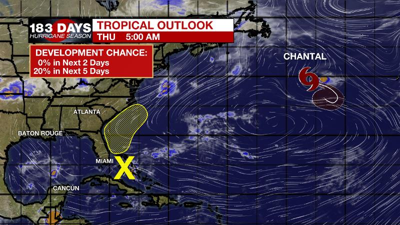
The Tropics: Tropical Depression Chantal is slowing and weakening in the North Atlantic. As of 5am Thursday, the storm had 35mph maximum winds and a minimum central pressure of 1010mb. Chantal will degenerate into an open low over the next two days. A trough of low pressure located over the central Bahamas is producing disorganized showers and thunderstorms. Some slow development may occur by early next week while the system moves slowly northwestward toward Florida. This system does not pose a threat to the local area.
THE EXPLANATION:
A weak trough in the upper levels will continue to provide the instability needed for scattered showers and thunderstorms to develop during the diurnally favored times. By Friday, a shortwave trough will move across the southern third of the U.S. as a plume of tropical moisture moves from east to west across the southern Gulf of Mexico. The advancing trough will draw the moisture northward and spread it along the Gulf Coast. The nature of this moisture will be tropical so drenching thunderstorms could lead to some nuisance flooding issues over the weekend. In general, 2 to 6 inches of rain is expected. The Weather Prediction maintains a 1/4 “marginal risk” for excessive rain. Locations that get caught under storm downpours and receive the higher end of those totals could experience some brief street and poor drainage flooding. Some of the stronger thunderstorms will also be capable of brief, gusty wind and frequent lightning. This pattern will continue until Monday. Then, more seasonal moisture levels will be restored and so too will be seasonal rain coverage. In the too early to call with confidence department, there are some signs that a weak front could provide slightly lower humidity by the end of next week.
--Josh
The WBRZ Weather Team is here for you, on every platform. Your weather updates can be found on News 2, wbrz.com, and the WBRZ WX App. on Apple and Android devices. Follow WBRZ Weather on Facebook and Twitter for even more weather updates while you are on the go.
More News
