

Latest Weather Blog
Lower Rain Chances for Friday/Tropics Remain Active
A much drier forecast today as rain chances will be limited this afternoon.
Today and Tonight: Expect a break from the heavy showers and thunderstorms today with only a 20-percent chance of rain in areal coverage being forecast. Sunny skies will be out in full effect, as will the heat and humidity, and this will once again drive the heat index past the 100 degree mark. Remember to take frequent breaks and remain hydrated if you are spending extended hours in the sun.
Up Next: Saturday through Tuesday the heat and humidity will continue to beat down on south Louisiana giving rise to an extreme heat index that will surpass he century mark. High temperatures are slated for the low to mid 90s with overnight lows in the mid 70s. Many will have an opportunity to dry out or perhaps continue the flood cleanup, but do note that the unrelenting summer heat means hydrating and frequent breaks will be a good idea. The chance of rain will return to 50-percent for both Saturday and Sunday, but lower to 20-percent chance by the start of the work week.
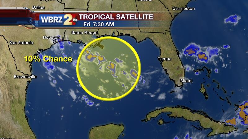
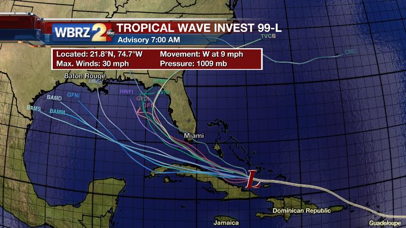
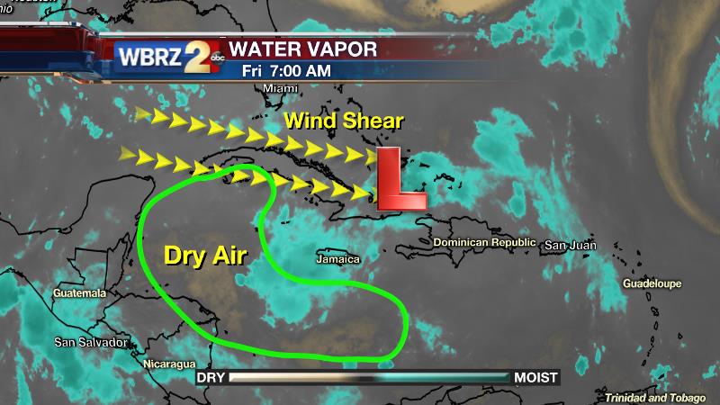
The Tropics: UPDATE As of 7 am Friday, The National Hurricane Center is watching a additional area of potential tropical development in the Gulf of Mexico just off the coast of Louisiana. The potential system is being given a 10-percent chance of development over the next 48 hours, and if the system should further develop into a tropical system then it will continue a westward progression towards the coast of Texas and will not affect Louisiana. We are also continuing to watch Invest 99L as it remains a disorganized area of showers and thunderstorms located just north of Cuba and moving toward the Florida Straights. Forward speed is currently WNW at 17 mph and winds have decreased to 30 mph. Without a well-defined center and winds below 39 mph, Invest 99L will not be classified as a tropical cyclone. Additionally, such poor organization makes it very difficult for often reliable forecast models to pinpoint a track or intensity. After encountering some dry air, conditions may become a bit more favorable for development as Invest 99L nears The Bahamas this weekend. The National Hurricane Center gives the wave a 50-percent chance of becoming a named storm over the next five days. Regardless of development, heavy rain and rain can be expected in those areas over the weekend. Beyond that, there is too much uncertainty for alarm in Louisiana at this time. You should double-check the preparations made at the beginning of every hurricane season and monitor the forecast for further updates.
Trending News
THE SCIENCE:
Forecast Discussion: The high pressure system centered over the Carolinas has moved slightly southwest placing portions of south Louisiana under the protective dome of sinking air. Wind flow in the gulf today is from east to west rather than the typical south-southeast to north. High pressure typically denotes clear skies and tranquil weather due to the sinking air that impedes cloud development, and if the skies are devoid of clouds then we can’t produce rain. The protective dome of high pressure will break down over the next 24 hours leaving South Louisiana once again exposed to the moisture surge from the Gulf of Mexico and this will cause rain chance to increase to 50-percent on both Saturday and Sunday.
--Josh
For updates, stay connected with Meteorologist Josh Eachus:
More News
