

Latest Weather Blog
Isolated strong storms, 1-2" rain by Saturday
Precipitation location will be the most important factor in determining if the next few days present new flooding issues.
THE FORECAST:
Today and Tonight: Scattered showers and thunderstorms are expected for your St. Patrick’s Day. While it won’t be a total washout, keep the umbrella close into the afternoon hours. One or two storms could produce hail especially north of the interstates, which is where the overall rain chances are highest. Highs will make it into the upper 70s. Overnight will be cloudy and damp with continued showers. Lows will be in the low 60s.
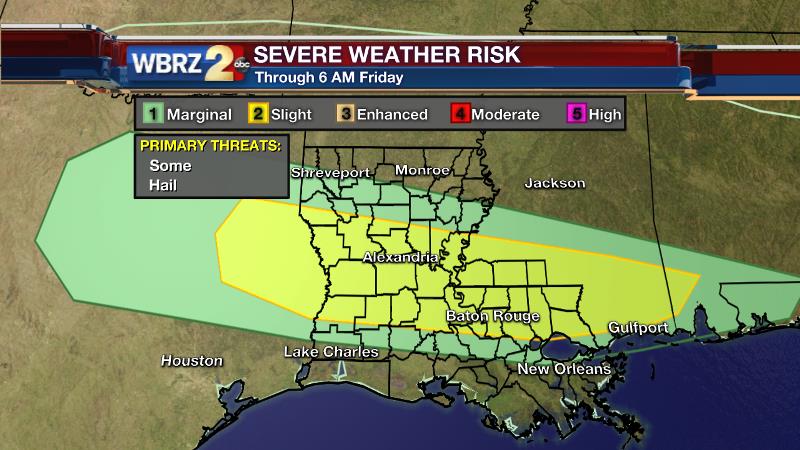
Up Next: Friday is shaping up to be the most unsettled frame of the week. Showers and thunderstorms will be more widespread with temperatures not making it beyond the low 70s. Showers will continue overnight into Saturday as a front clears the area and temperatures begin to fall. Most will find readings in the mid 60s by late afternoon. Sunday will start chilly in the mid 40s with sun and mid 60s in the afternoon.
Trending News
RIVERS:
|
River |
Current Level (Flood Stage) |
Forecast |
|
Amite, Bayou Manchac |
9.9’ (9.0’) |
Falling Below Today |
|
Amite, Port Vincent |
7.5’ (8.0’) |
Falling |
|
Amite, French Settlement |
4.9’ (4.0’) |
Falling Below by Fri. AM |
|
Mississippi, Baton Rouge |
36.5’ (35.0’) |
Rising to 36.7’ Sun. AM |
|
Mississippi, Red River Landing |
54.5’ (48.0’) |
Steady |
|
Atchafalaya, Morgan City |
6.1’ (6.0’) |
Rising to 6.8’ Sun. AM |
THE SCIENCE:
Forecast Discussion: As a stationary front is parked across the Louisiana/Mississippi border, waves of precipitation will be set off by disturbances overhead in the jet stream. The upper level energy will be key in setting off rain and forecast models are identifying Thursday Afternoon to Saturday Morning as the period with the most positive vorticity advection—and thus we peg that as the most favorable window for scattered shower and thunderstorm action. Severe weather isn’t out of the question—especially today—as enough instability exists near the front that a few storms could produce hail. That threat, and overall rain coverage, should be focused closer to the front today along and north of I-12. Overall, atmospheric moisture content is low, but several rounds of showers and thunderstorms will begin to add up. 1-2” of rain is expected though Saturday. But as we know, the nature of thunderstorms means localized downpours are possible. As long as the highest totals aren’t registered north of the lakes, in a short period of time, repeat flooding should not be a concern. By Saturday Night, a trough across the northern tier will progress southeastward providing the needed shove to wash that front south of the area. In addition, surface high pressure will build in from the northwest and northerly winds will bring much cooler air into the region. In fact, by Monday some traditional cool spots in the Florida Parishes and Southern Mississippi could be in the low 40s or even upper 30s! A quick rebound into the 70s is expected by Tuesday.
--Josh
More News
