

Latest Weather Blog
Increased threat for severe weather today, heavy rain tomorrow
The next three days will bring most of the activity that has been forecast since last week.
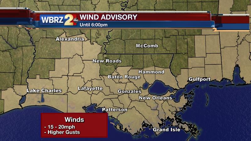
Today and Tonight: Expect showers and thunderstorms to increase through Wednesday. By the afternoon hours, a few storms could be severe with gusty wind and an isolated tornado possible. Locations west of Baton Rouge, and over the Atchafalaya Basin, run the greatest risk for strong storms. Heavy rain could be an issue as well. It will feel muggy with highs in the upper 70s. A wind advisory has been issued until 6pm for areas south of I-12 as gusts could exceed 25mph. Overnight, rain will continue, heavily at times with lows in the upper 60s.
Trending News
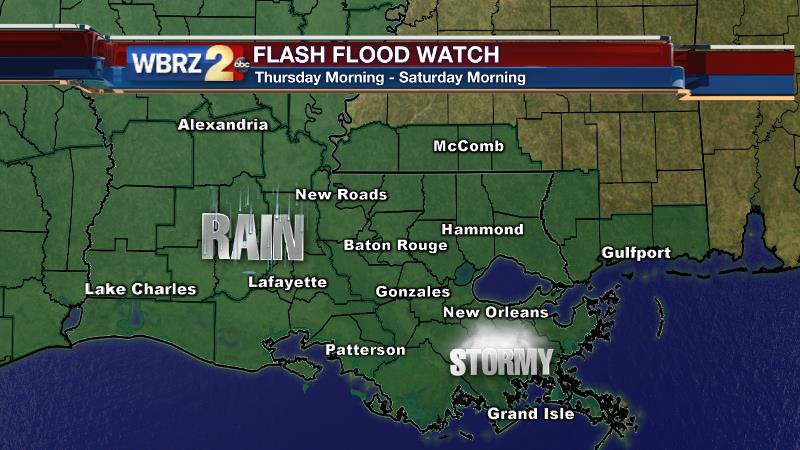
Up Next: Several inches of rain will be possible on Thursday and Friday with temperatures stopping in the mid 70s. Some showers may linger into Saturday Morning, but west to east drying is expected through the day. A general event total of 5-8” is expected with locally higher amounts possible. FLASH FLOOD WATCHES are in effect through Saturday Morning. This means conditions are favorable in the atmosphere to where heavy rain is possible over a specified area. Stay alert to the weather and think about where you would go if water begins to rise if you are put under a warning.

Additionally, a coastal flood advisory is in place as the combination of heavy rain and southerly winds will keep runoff from readily draining into Lake Pontchartrain and Lake Maurepas. Backwater flooding in the typical trouble spots could be an issue.
THE SCIENCE:
Forecast Discussion: An upper level trough has become entrenched well southward into Mexico. The associated surface low is translating from Central to Eastern Texas with a warm front positioned along the Gulf Coast. Today, a moisture loaded atmosphere will begin to squeeze out showers and thunderstorms, which are expected to become numerous as some daytime heating kicks in. If there is going to be severe weather this week—Wednesday brings the highest chance. Instability will peak in the afternoon with moderately high helicity values. A couple of thunderstorms could produce gusty wind or even a tornado. The “slight risk” area from the Storm Prediction Center encompasses Baton Rouge and points west over the Atchafalaya Basin which makes sense given a closer proximity to the surface low. Regardless, heavy rain looks to be the main concern with perceptible water values, or atmospheric moisture content, 200-300% of normal for this time of year. Strong low level winds will support training storm cells from Wednesday Night through Friday Morning as the local area lies east of a stalled surface low in East Texas. This is the time period in which heavy rain is most likely to occur with 4-6”+ possible through the frame. Additionally, continued southerly surface winds will create some backwater flooding issues along the Amite, Tickfaw and Tangipahoa Rivers on Wednesday and Thursday. As the storm system occludes on Friday Night, the axis of heavy rain will become disjointed from the parent upper low in South Texas as weaken as it pushes east. Positive vorticity advection and saturated low levels will keep clouds and showers in the forecast into Saturday, with a few downpours still possible early. The upper low will open up and finally eject east on Saturday Afternoon with the trough axis through by evening. By this time rain will shut down with an event total somewhere between 5-8” for most areas.
--Josh
Twitter: @Josh_Eachus
Google+: Josh Eachus
Facebook: Meteorologist Josh Eachus
More News
