

Latest Weather Blog
Heat rising, Earl strengthening
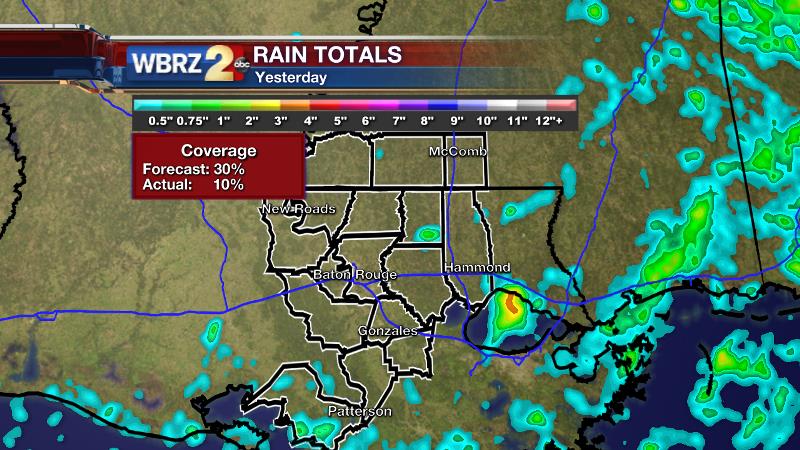
Tuesday made it to 97 degrees with 10 percent of the forecast area receiving rain. Showers did not reach quite as many backyards as anticipated. The forecast called for 30 percent coverage.
Today and Tonight: On Wednesday, partly sunny skies early will yield a high temperature in the upper 90s. With humidity causing the body to sense 105-110 degrees for much of the day, the National Weather Service has issued a heat advisory. As usual, you should focus on staying hydrated and not over-exerting outside. There may also be a few showers and thunderstorms. A little more action is expected than Tuesday and it is worth repeating that any storm may bring downpours and frequent lightning. Nighttime lows won’t budge from the upper 70s.
Up Next: Thursday through Sunday will be given a very similar forecast. Highs will be in the mid 90s with lows in the mid to upper 70s. Daily shower and thunderstorm development will begin along the coast with scattered action inland from the mid-morning to the late afternoon. No washouts are anticipated but when carrying on with the outdoor plans, please have an indoor option nearby in case of lightning!
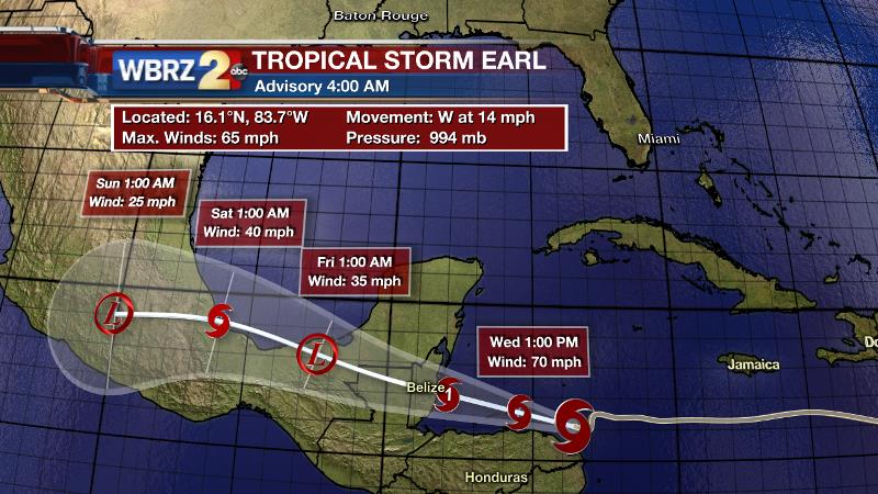
The Tropics: Tropical Storm Earl continues westward through the Caribbean Sea at 15mph. Showing signs of strengthening, Earl may briefly become a hurricane before making landfall in Belize Wednesday Night or Thursday Morning. Hurricane warnings have been issued for portions of Belize, Guatemala and Mexico. Along with hurricane force wind gusts, 8-12” of rain and a 3-5 foot storm surge are also expected.
Trending News
Keep up with the tropics this season! The WBRZ Weather Team provides the latest advisories from the National Hurricane Center, the moment they are issued. Follow us on Facebook and Twitter!
THE SCIENCE:
Forecast Discussion: A weak upper level ridge of high pressure will begin to retreat northwest today. There should still be a bit of subsidence left to keep rain coverage in the isolated category—especially in western locations. With a slightly weakened ridge, marine breezes and daytime heating will have better luck bringing convection each day, Thursday through the weekend. In addition, by Thursday, models are showing a few lobes of energy working around the periphery of the ridge that will likely enhance shower and thunderstorm development as well. Temperatures will be very close to seasonal normal.
--Josh
For updates, stay connected with Meteorologist Josh Eachus:
More News
