

Latest Weather Blog
Heat and midday rumblers through the weekend
Don't look for any weather surprises on this first weekend of August.
Today and Tonight: A few more showers and thunderstorms should be able to kick up on Friday. Scattered activity will develop around midday. About 50 percent of the 13 Parish, 3 County forecast area can expect rain. Of course, the location of these pop-up showers will be sporadic, as is typical in the summer. Highs will make it into the mid 90s. Overnight, there are signs that a batch of showers and thunderstorms moving through Mississippi could hold together and reach the local area—so don’t plan on a completely dry night as we’ve seen recently. Regardless, lows in the mid 70s are anticipated.
Up Next: The weekend will bring the same summer weather. Both days will be partly sunny with a few showers and thunderstorms moving around the area. We’ve had too many strikes and close calls already this year so please take lightning seriously—if you hear thunder, move inside a four-walled, roofed building until the storm passes. Neither day will wash out. Highs will be in the mid 90s with lows in the mid 70s.
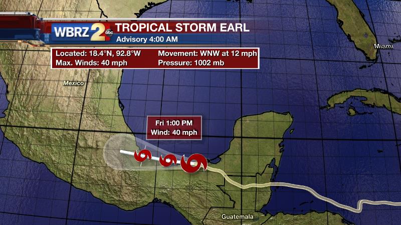
The Tropics: Tropical Storm Earl survived transit across the Yucatan Peninsula and has emerged into the Bay of Campeche. With 40mph winds and a motion off to the west at 15mph, the system will soon meet its demise in mountainous Mexico. Elsewhere, all remains quiet in the tropics.
Trending News
THE SCIENCE:
Forecast Discussion: Some influence of the upper level ridge may be leftover today in northern and western locations but elsewhere daytime heat and marine breezes should activate scattered convection by the afternoon hours. Overall, the forecast area should see a bit more coverage than the previous few days. Both the GFS and ECMWF model have been indicating that a robust area of positive vorticity advection will drop northeast to southwest through the area overnight. In doing so, it could be expected to create a round of nocturnal storms. It wouldn’t at all be surprising to see a cluster of showers and thunderstorms pass through between midnight and midday Saturday. For the weekend, the ridge will be somewhat suppressed and isolated to scattered showers and thunderstorms are anticipated—especially during the afternoon hours. Some upper air divergence and a few waves of energy will support more development next week and thus high temperatures may come back to more normal readings in the low 90s.
--Josh
For updates, stay connected with Meteorologist Josh Eachus:
More News
