

Latest Weather Blog
Grab the umbrellas, lose a layer
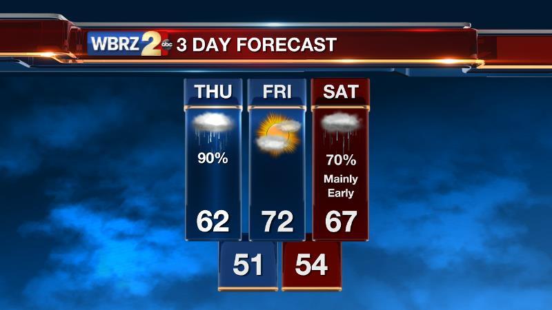
Briefly milder and wetter weather will extend into the first half of the weekend.
THE FORECAST:
Today and Tonight: A round of rain can be expected Thursday, with a clap of thunder possible also. Only an inch or so will fall around the region and severe weather will not be an issue—therefore, this is not a high impact event. Most of the rain will fall early, then showers will become scattered to perhaps only isolated into the afternoon. Highs will end up in the mid 60s. Overnight, clouds will linger with a low in the low 50s.
Up Next: Friday will feature a partly sunny afternoon and a temperatures top out near 70! The next round of showers is anticipated overnight into the first half of Saturday. An early high temperature in the upper 60s seems likely with much cooler air quick to follow. Since the front is expected to pass by afternoon, temperatures will begin to fall late with Sunday Morning lows back into the upper 30s. The afternoon will be mostly sunny and chilly.
Trending News
THE SCIENCE:
Forecast Discussion: A shortwave trough axis will lift away to the northeast today. Negative vorticity advection behind this feature will tend to dampen rain showers through the afternoon. Some lingering low level moisture will maintain a low cloud deck during the overnight hours. Into Friday, as the region sits between upper level features, some sunshine will be possible and the upward trend in temperatures will continue thanks to southerly surface winds. Low 70s will be easily achievable on Friday Afternoon for locations that receive ample sunshine. A second upper trough will spin across the Midwest on Friday Night with a trailing surface cold front. This system will be rather quick and thus the window of opportunity for showers looks brief—about 12 hours into the first half of Saturday. Cold air advection will ramp up beyond the frontal passage as a strong 1030mb surface high dips from Canada to Texas Saturday Night through Tuesday. Temperatures could have a tendency to fall during the afternoon hours on Saturday depending on the punctuality of cold air behind that front. Either way, northerly winds will transport cool air to the Gulf Coast will temperatures running below average through early next week. We’ll monitor the possibility of a couple more overnight freezes Monday and Tuesday Mornings.
--Josh
Stay connected with me… share your thoughts!
Twitter: @Josh_Eachus
Google+: Josh Eachus
Facebook: Meteorologist Josh Eachus
More News
