

Latest Weather Blog
Front coming, major changes are not
Two more warm, almost hot, days can be expected before a cold front changes the air mass by Friday. Rain chances will stay slim. Did you sense a cooler than average summer? How about a wetter than average summer? One may have led to the other! Read more about that, HERE.
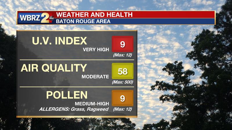
Today and Tonight: Wednesday will bring abundant morning and afternoon sunshine leading to a high temperature in the low 90s. It will feel sticky outside, as winds will be light and easterly. Wednesday night will be calm with a low temperature in the low 70s. Due to very little rain over the last several days, ragweed and grass allergens will stay high.
Up Next: A weak cold front will pass through on Thursday, likely without rain. As the air mass dries and any cooler air lags behind the front, high temperatures will still reach the low 90s. By Friday though, the local area will feel a drop in humidity. Lower dew points will allow overnight temperatures to fall into the mid 60s while afternoon temperatures reach the mid 80s Friday through Sunday. Outdoor plans for the upcoming weekend, including LSU Homecoming and Southern on The Bluff, appear to be in great shape.
Trending News
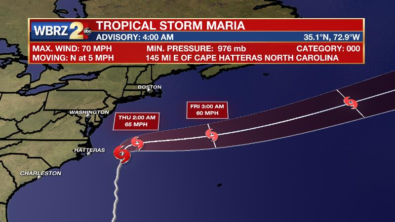
The Tropics: Tropical Storm Maria is positioned 150 miles east of Cape Hatteras with a minimum central pressure of 976mb and maximum sustained winds of 70mph moving north at 5mph. Tropical Storm conditions may continue along the Outer Banks of North Carolina and storm warnings have been posted through Wednesday. 2-4 feet of storm surge, 1-2 inches of rain and wind gusts over 40mph will be possible Tuesday and Wednesday. Hurricane Lee is a small but strong storm with 110mph winds in the central Atlantic. Going nowhere fast, Lee will remain a fish storm, eventually curving out to sea.
THE EXPLANATION:
A weak upper level ridge will position over the central Gulf Coast through Thursday as a shortwave trough crosses the northern tier of the country. This weak upper trough will drag a trailing surface cold front across the CONUS and send it through the local area on Thursday. Due to the upper level ridge in place, subsidence and drier air will make it difficult for any kind of frontal lift to generate showers and thunderstorms during passage. Prior to that front, the ridge will promote unseasonably warm temperatures with highs working well into the low 90s. On the other side, temperatures will be closer to average with highs in the mid to upper 80s and lows in the mid 60s Friday to Sunday. The bigger change from the front will be in humidity as dew points fall into the lower 60s. Therefore, although warm, Friday to Sunday will feel a bit more comfortable. Even though significant weather is not expected Sunday to Tuesday, the forecast is a little tricky with respect to rain chances. The local area may end up between a weak ridge to the northwest and a weak trough to the southeast. In between those two features, the central Gulf Coast could see a slight increase in rain chances if deep layer moisture can return in time. This portion of the forecast will become a bit clearer as we get closer. Right now, the features in question are too subtle for the models to sample well.
--Josh
The WBRZ Weather Team is here for you, on every platform. Your weather updates can be found on News 2, wbrz.com, Facebook, Twitter and the WBRZ WX App. on Apple and Android devices.
More News
