

Latest Weather Blog
Fore... nice days in a row
Call the Chamber of Commerce; very nice weather is on tap through the weekend. Not only is sunshine expected, but temperatures will be at or even below average with no humidity. Whether you will be attending an event, getting some outdoor exercise or playing a round of golf inspired by The Masters, all plans are a go!
THE FORECAST:
Today and Tonight: Thursday will be sunny and cool with high temperatures in the low 70s and northwest winds of 5-10mph. Hopefully, your light jacket is not tucked too far away. Beneath clear skies, overnight low temperatures will fall back into the upper 40s!

Up Next: Have outdoor plans this weekend? No? Well, you might want to make some! After a cool, sunny Friday, for the first time since March 18 and 19, both Saturday and Sunday will be dry. Clear skies are expected throughout. After a cool Saturday morning in the upper 40s, temperatures will climb into the upper 70s in the afternoon. Sunday will be slightly warmer with highs back in the low 80s. The next rain chance looks to hold off until Tuesday.
Trending News
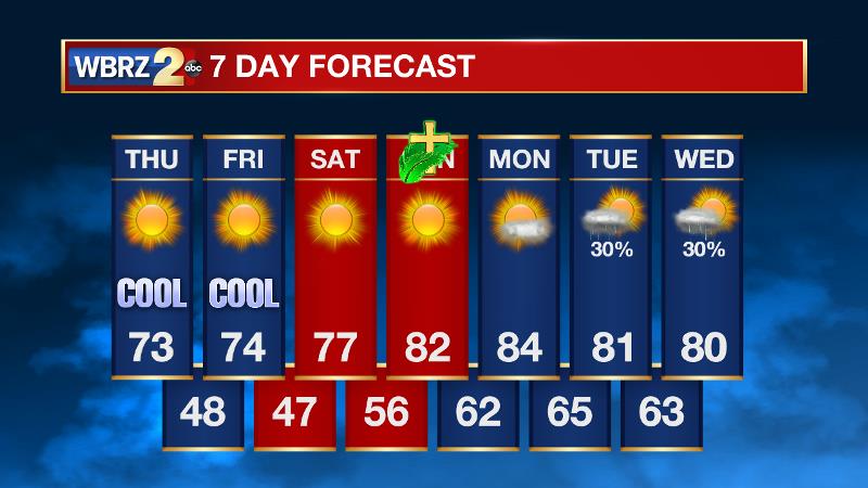
THE SCIENCE: An upper level trough is trenched in the Southeast with a surface high pressure in the Mountain West. Northwesterly flow at all levels is promoting a cooler and drier air mass which will stay in the local area through Saturday. Very low moisture content should result in almost all clear skies. Light northerly winds on Thursday and Friday night with dew points in the low 40s will allow for ample radiational cooling and low temperatures to fall back into the upper 40s north of I-10. By Sunday, the surface high pressure system will migrate to the Eastern Seaboard and return flow will commence. High temperatures will rebound above average on Sunday afternoon—back into the low 80s. Low level moisture will allow some cloud development on Monday Afternoon. The next shortwave trough is pegged for late Tuesday and Wednesday. Early in the game, both the GFS and ECMWF have this thing on a pretty southern track which would suggest at least some chance for severe weather, but again it is way too earlier to make any definitive calls on that system.
--Josh
More News
