

Latest Weather Blog
Flooding, severe storms possible this weekend
The National Weather Service has issued a FLASH FLOOD WATCH for the entire WBRZ viewing area in effect from 7am Saturday to 7p Sunday. This includes the Parishes of East Baton Rouge, Ascension, Assumption, East Feliciana, Iberville, Livingston, Pointe Coupee, St. Helena, St. Mary, Tangipahoa, West Baton Rouge and West Feliciana in Louisiana and the Counties of Amite, Pike and Wilkinson in Mississippi.
A FLASH FLOOD WATCH means conditions may develop that lead to rapidly moving and rising water. Be alert to any warnings, move to safer ground if one is issued and NEVER drive your car through a flooded roadway.
Rain and thunderstorms will overspread the region from west to east through Saturday Morning and into the afternoon, with episodes of rain continuing through Sunday. A very moist air mass will be in place as a low pressure system moves into the region. The first round of rain and storms could arrive as early as dawn on Saturday. Another wave is expected for the second half of the day and could last into the overnight hours. Because a cold front associated with this storm will be very slow to move across the Gulf Coast, there will be ample time for 2-4” of rain to fall before it kicks through. Where heavier pockets persist, there could be locally higher amounts. Showers will linger behind the front on Sunday.
Into next week, local rivers will again have to be monitored.
Trending News
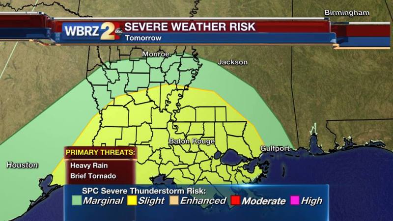
In addition to the heavy rain, enough wind shear is in place that a couple of storms could turn severe, producing a brief tornado. The most likely window for any stronger thunderstorms is Saturday Afternoon and Evening.
All outdoor plans on Saturday should have a contingency in the event of flooding rain and lightning. Should you hear thunder, lightning is close enough to strike and you should move indoors.
Stay connected to the WBRZ Weather team on FACEBOOK and TWITTER should additional bulletins, such as watches and warnings, be issued. You get our latest forecasts HERE and track along with live weather on the WBRZ WX app.
Facebook: WBRZ Weather
Twitter: @2StormView
More News
