

Latest Weather Blog
Drought to Deluge: Gulf Coast soaker just a start?
The shift is on along the Gulf Coast.
For those tuned in to climate changes, this is no surprise. For others, get ready for wholesale alterations.
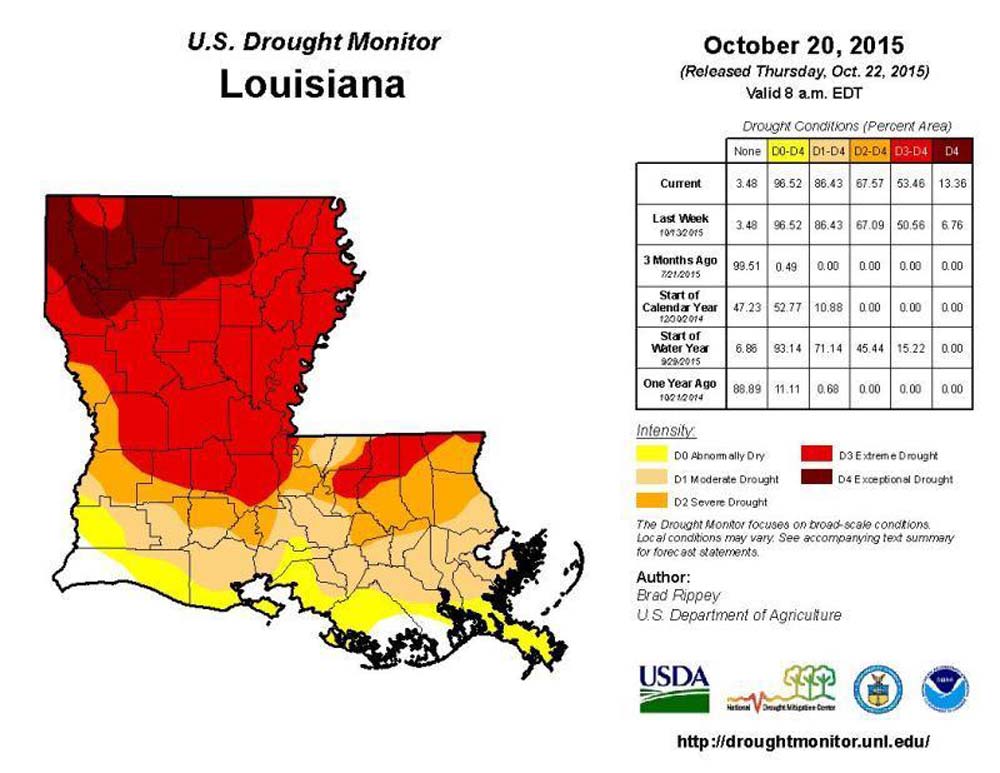
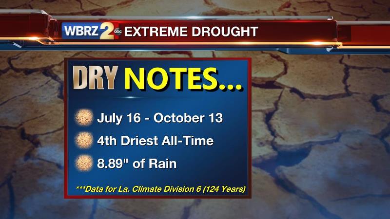
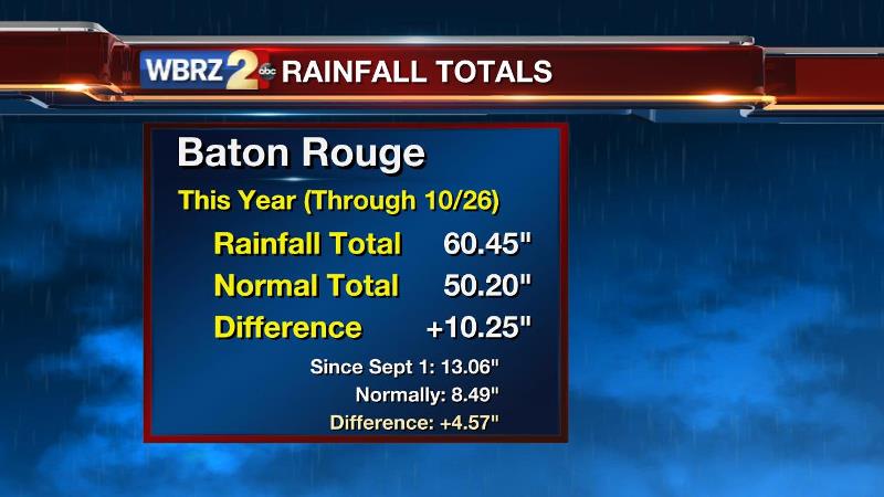
Summer was dry. Typical afternoon convection was squashed by a persistent mid-level ridge from July to October. A comfortable annual rain surplus evaporated to nil by Early Autumn. Extreme to exceptional drought plagued Louisiana over that three month period with Louisiana’s sixth climate division, including the city of Baton Rouge, running almost 9” shy on usual rainfall through the period. Less than an inch of rain fell along the I-10/12 corridor from Mid-September into Mid-October. That dryness and low humidity combined with gusty winds helped to fuel a number of wildfires across portions of northern Louisiana. Statewide burn bans were issued. In Mississippi, field reports mentioned that the planting of winter grazing fields had been delayed. Crop yields were down, cattle producers had to hay feed much earlier than usual due to loss of green forage, general farm ponds receded, and many established landscape trees and shrubs were damaged.
Trending News
With a growing season that typically continues until around Thanksgiving, brown lawns and parched plants suggested that a desolate summer and the normally dry fall conditions would be too much to overcome.
Then, this happened:
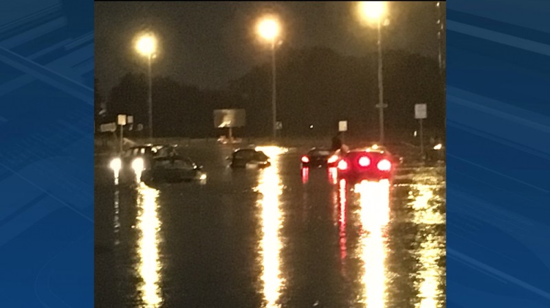
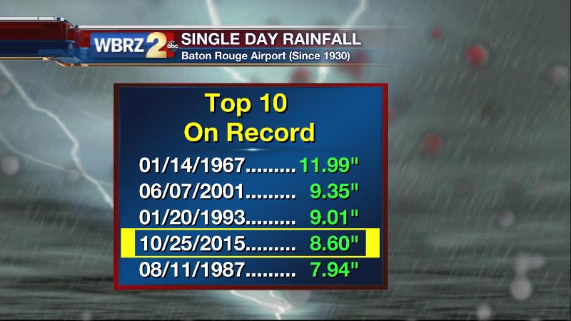
On back to back days, Oct. 24 and 25, Baton Rouge set daily rainfall records of 2.14 inches and 8.60 inches—the latter of which was the fourth largest single day total in the city’s recorded history. The cause could be traced to an upper low that tapped into an abundant moisture source via the remnants of Hurricane Patricia.
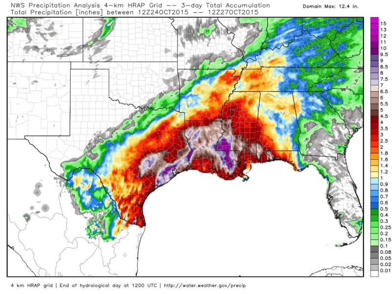
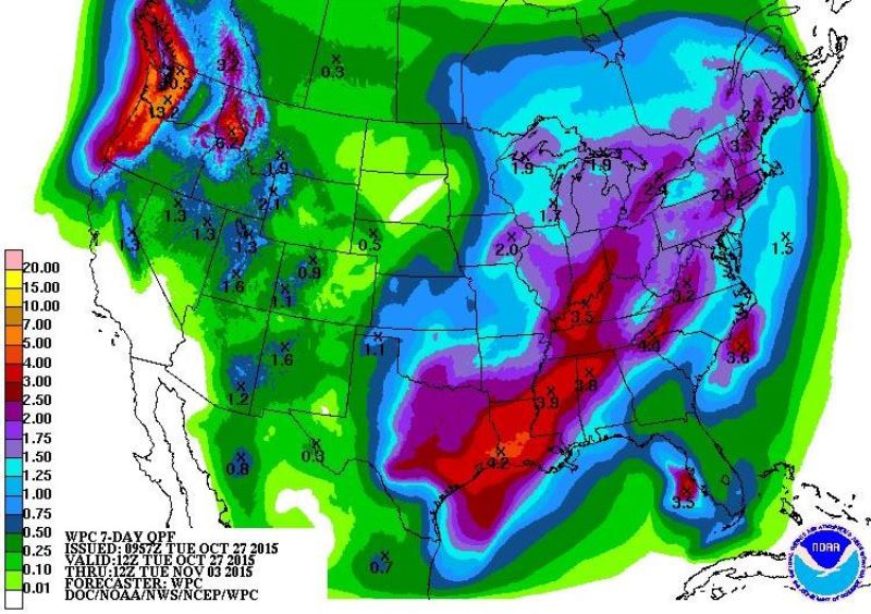
As noted by Louisiana State Climatologist, Dr. Barry Keim, perhaps most remarkable about the deluge was the large geographic area that had experienced a 10 to 25 year rain event. Areas between Baton Rouge, Houma and Slidell Louisiana to Vicksburg Mississippi registered event totals of 7-12”.
With the subsequent runoff, dry area rivers bulged creating prompting flood warnings in typical trouble spots. After one weekend spent indoors, much of the region went from “extreme drought” to what Keim expects will be “no drought” when the latest monitor is released.
Those previously existing drought conditions and gradual soaking (as opposed to a high-rate torrent) kept flash flooding to a minimum—but that all may soon change.
The presence of El Niño is no secret. It has been tucked away in the Equatorial water of the Pacific Ocean for months with passive effects not easily recognized. While storm numbers aren’t historically low, accumulated cyclone energy is down in the Atlantic Ocean as was anticipated. For summer climate in the United States, weather patterns aren’t drastically changed. The culprit for active weather in the Southern United States, the sub-tropical jet stream, stays in the tropics and creates harsh conditions for tropical cyclones. But during an El Niño winter, that jet stream is held north due to the warmer waters of the Pacific Ocean. The result is an active, stormy pattern along the Gulf Coast. Depending on how many waves develop in the jet, sometimes a barrage of storm systems can march across the country—one after another.

Low and behold, an explanation of NOAA’s cooler and wetter winter outlook from Texas eastward across the Gulf Coast. They have forecast for the coming months what we are now seeing emerge as reality—a wetter, more active pattern.
One big rain event behind, and another looks to be on the way. While there are slight timing and intensity differences between the GFS and ECMWF forecast models, the next Gulf Coast rain-maker is pegged for Halloween. Treaters will be greeted with tricks in the form of showers and thunderstorms.
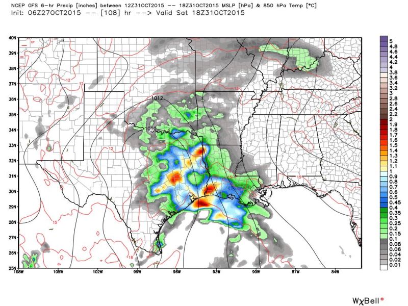
Typical of cool-season cyclogenesis, an upper level wave will traverse the baroclinic region along the Texas Gulf Coast. By Saturday, a surface storm will develop, lifting a warm front inland through the Gulf States with the surface low and trailing cold front expected to cross the region between Sunday and Monday. Rich with tropical moisture from the Gulf, this storm will likely produce another bout of heavy rain somewhere in the region.
In a pattern like this, the question of flash flooding isn’t if, but where.
One down, another to come, indeed a weather shift along the Gulf Coast has only just begun.
More News
