

Latest Weather Blog
Cool second half of the week
A brief, slight chance of showers will be it for the remainder of the workweek. Dress for much cooler temperatures Wednesday to Friday.
THE FORECAST:
Today and Tonight: A ragged cold front will travel through on Tuesday, but only bring spotty showers to the area. Any rain will be very light and many locations will go precipitation free. Skies will stay mostly cloudy with highs nearing 70 degrees prior to the frontal passage. Look for clearing and cooling overnight with thermometers backing into the 40s.
Up Next: Surface high pressure will follow closely behind the front, which will break clouds up into Wednesday. Sunny skies return through Thursday, with highs stopping in the mid to upper 50s and lows in the 30s. This weekend, a low pressure system will move across Louisiana. This will bring scattered showers through Saturday, as the low merges with a cold front from the northwest. We cannot rule out an isolated thunderstorm, but the majority of the system will just be rain. Below average temperatures will last into next week.
THE EXPLANATION:
A weak upper level trough will move from the Midwest across the Mid-Mississippi River Valley on Tuesday with an associated cold front. This boundary may stir up a few showers but compared to the last several systems, this one is lacking moisture and vertical transport. Some spots could even miss rain. Those that do receive a shower can expect minimal amounts. Thermometers will drop considerably on the other side of the front with highs and lows about 10 degrees below normal to wrap up the week. On Friday, conditions will begin to transition as a ridge shifts east, and a vigorous shortwave trough moves into the Southern Plains. Increasing positive vorticity advection will overspread the region, and an increase in mid-level moisture is expected. This will allow for thickening cloud cover through the day, but there should be just enough dry air in the low levels to prevent showers from developing. A surface low will develop over Texas and gradually strengthen as it moves across the Mid-Mississippi River Valley.
Trending News
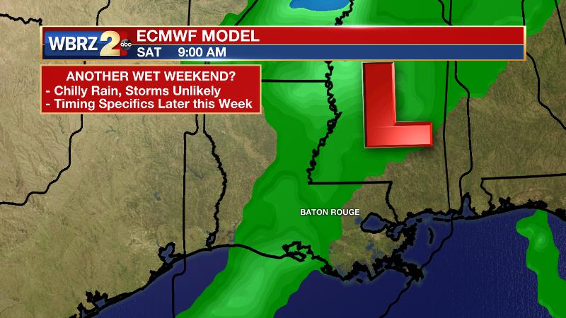
Southerly winds will pull moisture into the region and with increasing uplift due to the storm system, widespread showers will form. An associated cold front will drag across southeast Louisiana and southwest Mississippi later Saturday with one last push of rain. Instability should be low enough to prevent thunderstorms. Once the front clears Saturday night, sinking, drier air will take hold on Sunday. Clearer weather will result, and temperatures should cool slightly back into the 50s. Deep layer northwest flow will keep these clear and cool conditions in place through Monday.
--Dr. Josh
The WBRZ Weather Team is here for you, on every platform. Your weather updates can be found on News 2, wbrz.com, and the WBRZ WX App. on Apple and Android devices. Follow WBRZ Weather on Facebook and Twitter for even more weather updates while you are on the go.
More News
