

Latest Weather Blog
Cold and rain return, may mix with sleet before ending
The weather will turn around quickly on Thursday as clouds build and showers arrive later in the afternoon. Nasty weather is in store for Friday with rain showers, falling temperatures and perhaps a bit of sleet mixing in before the precipitation wraps up.
THE FORECAST:
Today and Tonight: Overcast skies will prevent thermometers from climbing past the upper 50s. Showers are possible as early as the evening hours. As wind stay light, overnight will remain cloudy with a few showers and lows in the upper 40s.
Up Next: As clouds and pockets of rain persist on Friday, cold air advancing from the north will guide thermometers down through the day. Expect an early high in the upper 40s with readings in the upper 30s by evening. After dusk, there could be a brief period of sleet, and possibly freezing rain, north of a New Roads to McComb line before precipitation ends during the pre-dawn hours of Saturday. No accumulations and no impacts are expected. Sun will be out for the remainder of the weekend but it will stay cold with highs in the mid 40s and lows in the mid 20s Sunday Morning.
Look for in-depth analysis through the day right HERE and from WBRZ Weather on Facebook and Twitter.
Trending News
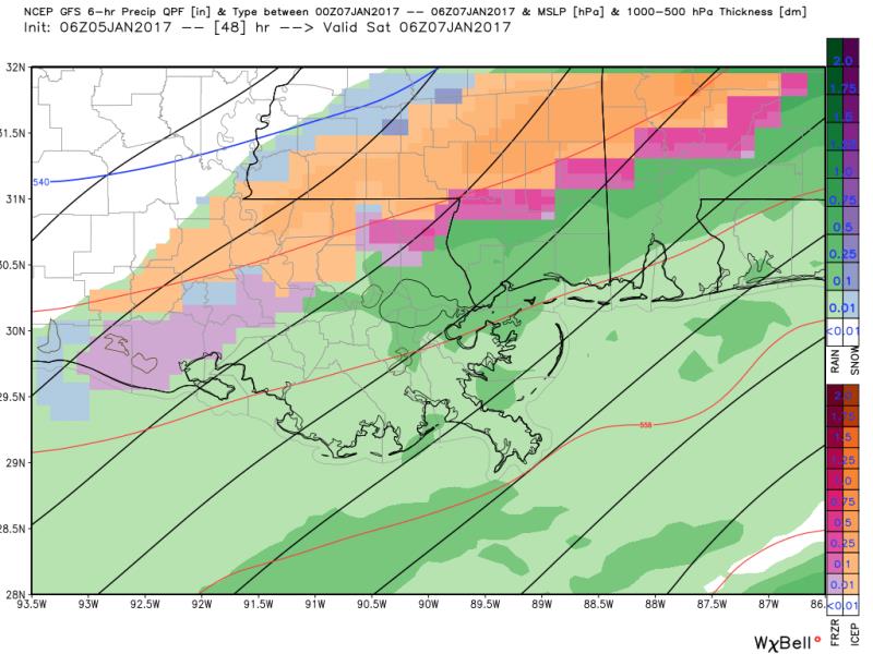
THE SCIENCE: Mid-level moisture return will begin on Thursday as a warm front sets up in the Gulf of Mexico. Cloud cover will build in through the day and upsloping moisture could result in rain showers as early as Thursday Evening. An associated shortwave trough in the southern stream will move into the region Friday. A surface low will develop in response to this upper energy and track from the South Texas Coast northeastward toward the Florida Panhandle by Saturday Moring. Forecast models are in good agreement on rain showers throughout Friday. As this is happening, a northern stream trough will deepen into the Southeastern United States advancing even colder air into the region. Temperatures are expected to fall through the day Friday with a high occurring in the morning hours and thermometers in the mid 30s by evening. Some light precipitation is expected to linger into the pre-dawn hours of Saturday Morning before ending. Herein presents the biggest forecast challenge of the period. Could there be any wintry weather? At this time, both the GFS and ECMWF models are suggesting a brief transition to a wintry mix Friday Evening before precipitation ends shortly after midnight. As is typical in the Deep South, a number of ingredients must align perfectly for this to occur. First, a warm layer in the lower levels exceeding 3 degrees Celsius suggests complete melting of any snow falling through the atmosphere. Just below that, will be another freezing layer possibly deep enough for liquid to refreeze into sleet pellets. This becomes more likely farther north and west of Baton Rouge. Second, surface temperatures are expected to stay above 32 degrees Fahrenheit everywhere Southwest Mississippi. Therefore, locations south and east of Baton Rouge along I-12 should expect rain only. In Baton Rouge, rain and a few ice pellets are possible. North of a New Roads to McComb line, a rain and sleet is expected with the possibility of a brief period of freezing rain and a few wet snowflakes. Precipitation will rapidly end from Northwest to Southeast, before dawn on Saturday with sun back by the morning. Very cold air will stay in place though with thermometers staying in the 40s on Saturday and dropping into the mid 20s on Sunday Morning. Gradual moderation is expected Monday and Tuesday as a surface high moves toward the East Coast and winds shift southeasterly.
--Josh
More News
