

Latest Weather Blog
Chilly start to weekend, freezing temps expected next week
Chilly temperatures will gradually moderate through the weekend. However, a much more potent cold blast will come early next week.
THE FORECAST:
Today and Tonight: Clouds will be stubborn to break on Friday as a cold front crawls into the Gulf of Mexico. However, from a travel perspective, the weather should be quiet and cooperative for Tiger fans driving to Tuscaloosa. Due to the lack of full sunshine and light, northerly winds, high temperatures will stay in the upper 50s. Overnight, skies will clear with low temperatures in the upper 30s.
Up Next: Cool and dry conditions are anticipated for both the LSU and Southern football games on Saturday afternoon. Expect a pair of sunny weekend afternoons in the mid 60s to low 70s. An even colder air mass will then race into the region next week. A cold front will bring clouds and showers late Monday into early Tuesday followed by sharply colder temperatures. Highs will struggle to leave the 40s on Tuesday and Wednesday. The first freeze of the season is likely on Wednesday morning, and a hard freeze is not out of the question. Historically, the average first freeze occurs on November 24. The earliest freeze recorded was October 28, 1957.
Our first freeze is on the way! Remembering the "4 P's" in cold weather, let's use part of this nice weekend to make preps for the cold days and months ahead. #BatonRouge #LaWX #MsWX pic.twitter.com/sM6IagomWn
— Josh Eachus (@DrJoshWX) November 8, 2019
Trending News
The Tropics: For the North Atlantic, Caribbean Sea and the Gulf of Mexico, tropical cyclone formation is not expected during the next 5 days. This is the final official month of hurricane season.
THE EXPLANATION:
Due to the basin of the coldest air aloft staying north and east of the local area, cold air advection at the surface may set up an inversion (temperatures cooler at the surface than aloft) with lingering mid-level moisture making it difficult for clouds to break on Friday. Lows will bottom out in the upper 30s on Saturday morning. While cooler than average temperatures will prevail, thermometers will quickly moderate through the weekend. An unusually deep pool of cold air aloft will spill into the Eastern U.S. on Monday.
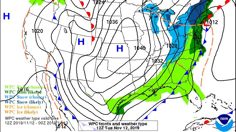
This will send a cold front through the local area. Moisture return will be very limited ahead of that front, so rain coverage and amounts will be low once again. The bigger story with this front will indeed be temperatures. This upper level cold pool will reach the local area and translate to much colder surface temperatures with some staying power. Model guidance points to an air mass anomalous enough such that freezing temperatures are a real possibility. This is not terribly early for a freeze but would be for a hard freeze and there is some guidance suggesting the mid 20s are a possibility. Both Tuesday and Wednesday may fail to leave the 40s for high temperatures. Forecast models want to end the precipitation on Tuesday as a brief, light period of sleet but with surface temperatures in the upper 30s and the ground well above freezing, problems are unlikely if this low chance scenario materializes.
--Josh
The WBRZ Weather Team is here for you, on every platform. Your weather updates can be found on News 2, wbrz.com, and the WBRZ WX App. on Apple and Android devices. Follow WBRZ Weather on Facebook and Twitter for even more weather updates while you are on the go.
More News
