

Latest Weather Blog
Avoiding the hype while staying informed
For many, this time of year brings back painful memories. So many life-changing storms have occurred through the last week of August and the first week of September. Even though the peak of hurricane season is in the second week of September, it seems like the ones that make history occur slightly earlier. I even know several meteorologists personally who specifically request this time off so they can "chase" any potential storms that may develop.
Some recent storms that come to mind that impacted our state in this time frame include Isaac (August 28th 2012), Gustav (September 1st, 2008), Katrina (August 29th, 2005) and Andrew (August 26th, 1992).
With some Louisiana residents already on edge after last week's storm, and approaching the anniversaries of many horrible memories, some media outlets and amateur "meteorologists" have been hyping a nonexistent storm for ratings or "likes" and "follows" on social media.
Let me preface by saying that the storm approaching that Caribbean at this time (Invest 99-L) is certainly holding our attention, and some models do indicate that it could influence our area, but to even mention that possibility on the air at this point is irresponsible. This is even more the case for a professional whose job it is to keep the public informed as the "face" of meteorology; your local weatherman.
That being said, sometimes your local broadcast meteorologist can be the best resource concerning a tropical system because they are in fact local. They know your area, and you know their credentials. They can explain these difficult situations clearly and efficiently. Your local National Weather Service office, in conjunction with the National Hurricane Center is also a great resource. The official forecasts from the National Hurricane Center have only become more accurate with time, even in the years since Katrina.
The national media tends to sensationalize (or completely ignore) weather stories. If the storm doesn't come to fruition, they move on as if it never even happened like a hit-and-run, and the local meteorologist is left to blame. This also goes for amateur meteorologists that you may find on social media. The stigma of a weatherman who is "paid to be wrong" is only augmented by these viral social media posts. A few hurricane blogs are great, any many colleagues including myself actually follow them for diverse opinion, but most are weather enthusiasts or freshman meteorology students who want to be known as "the one who got it right." I never understood that, even in college. What has always been more important for me, and my colleagues here at WBRZ, was a clear and uniform message. No matter if you get your info from the news, National Weather Service, or emergency management, you should receive the same message and you should receive the truth.
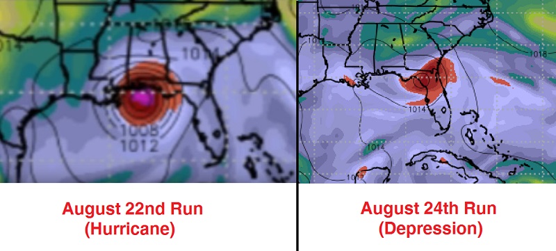
This brings us to the storm entering the Caribbean. The title photograph is a photo of the American (GFS) weather model showing a hurricane hitting the Gulf Coast. This image was found on an amateur meteorologist's "vlog" on Monday, August 22nd. For someone who may not understand computer models, this can be frightening. However, see the latest "run" from the exact same model from Wednesday morning. Not only has it changed location, but the intensification has greatly decreased. You can see that by the amount of circles.
Trending News
It's important to stress that weather models are only tools and should only be used as such. They should not be used as a crutch as some meteorologists tend to do. Knowledge of patterns, trends, geography, and other opinions are necessary for an accurate forecast, like Nash Roberts of New Orleans used to do. In fact, it is very difficult for a model to produce an accurate forecast without the storm having a well-defined center of circulation. At this moment, Invest 99-L is not well defined. Let's look at some other computer models and see how they develop this storm which may potentially be named Hermine (her-MEEN).
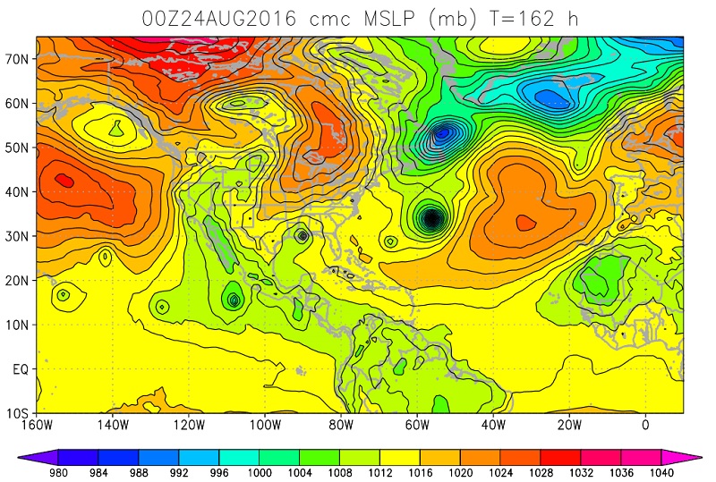
Below is the Canadian (CMC) model which always tends to blow up any disturbance into a hurricane. It's a good tool to see where a storm could possible form, but it tends to be fairly inaccurate in forecasting intensity and landfall. If you look at the Gulf Coast, it does in fact show landfall in southeast Louisiana, at a relatively weak intensity. That's not good, but this would also be irresponsible to show on the air because this storm is too far out, and this is just one model possibility.
Here is the European (ECMWF) model. This one, in addition to the American, is generally well respected. In this model run, the storm actually becomes a major hurricane, making landfall in southeast Texas. This one has appeared on various weather blogs in recent days.

Here is the Hurricane Weather Research and Forecasting model (HWRF). While the other models shown are used in tropical predictions, they are also used in general weather patterns all through the year. The HWRF was designed specifically to forecast hurricane landfall and intensity. It also is used just as guidance for any hurricane forecast. The HWRF currently shows a category 1 hurricane making landfall in southern Florida, and not affecting Louisiana.

The last model that I'll be showing here is the Geophysical Fluid Dynamics Laboratory (GFDL). According to the National Weather Service, the GFDL "has consistently been one of the top-performing models for the prediction of hurricane tracks." What the GFDL shows is the storm straying just east of Florida, with its intensity all but vanished.

With reference to the models, most preliminary forecasts agree that there is a noteworthy trend of a western orientation of this storm track. Whether that means landfall in Houston or Miami, it just can't be answered at this point. If you show only one of these models to the general public, and that model happens to show a hurricane in the Gulf, then many will panic. This again, only exacerbates the stigma that "the weather man is always wrong." Most of the time this is not the case. Like any broadcaster, the WBRZ Weather team often hears this claim. Yet when confronted, the accuser is quick to apologize when we provide them with previous blogs and video forecasts posted days prior and which are freely available.
In conclusion, we want you to be aware that there is a storm in the Caribbean and there is a potential for it to threaten the Gulf of Mexico, but at this time, it is just too early to say exactly what it will do. It has a fight to put up as it crosses the high terrain in the Caribbean and some dry air, but it's not impossible for it to survive. The National Weather Service Air Force Reserve Hurricane Hunter aircraft will be flying through the storm late Wednesday morning to investigate the disturbance.
The best thing to do is to have a plan, and to do it now. We'll keep bringing you truthful updates without the hype as the situation changes because we desire your trust and respect more than your Facebook "likes."
-RGIII
B.S. Meteorology
M.S. Climatology (In Completion)
~~~
Facebook: Meteorologist Robert Gauthreaux III
Twitter: @RG3wbrz
~~~
En Español: Meteorólogo Roberto Gauthreaux III
In American Sign Language: Meteorologist Robert Gauthreaux III - ASL
More News
