

Latest Weather Blog
Active weather expected Thursday, Saturday
The WBRZ Weather Team is monitoring two threats for severe thunderstorms and the next shot at cooler temperatures.
THE FORECAST:
Today and Tonight: Another cloud filled sky is expected on Wednesday with a better shot at showers into the evening and overnight hours. High temperatures will chug into the mid 70s once again with southeast winds of 5-10mph. Showers and thunderstorms will increase in coverage and intensity overnight with temperatures stuck in the upper 60s.
Up Next: Strong thunderstorms will be possible on Thursday. While this threat is on the lower end of the risk scale, keep in touch with the forecast in case any watches or warnings are issued. Either way, rain is expected across the area with high temperatures not escaping the low 70s.
Trending News
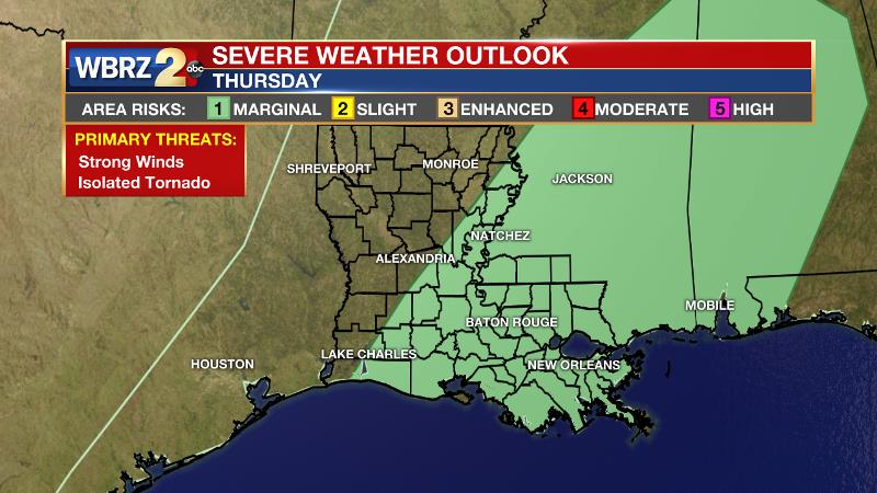
The National Weather Service Storm Prediction Center as placed the entire forecast area under a *marginal risk* for severe weather. This means isolated severe storms are possible within the forecast area. On a scale of 1 (lowest) to 5 (highest) severe weather threat, this event is a 1. Another way of describing the threat is that there is a 5 percent chance of experiencing severe weather within 25 miles of a given point in the risk area.
Possible Threats:
1) Downpours – heavy rain will occur with storm cells embedded in a larger area of precipitation.
2) Gusty Wind – in storms that turn severe, wind gusts could exceed 58mph.
3) Isolated Tornadoes – ingredients are not ideal, but enough wind shear in the atmosphere means that a tornado cannot be ruled out.
Precipitation:
Up to 2” of rain could fall anywhere within the 13 Parish, 3 County Forecast Area—especially where the heaviest storms occur. At minimum, all locations should receive 0.5” of rain.
Estimated Timeline:
Rain will become widespread and heavier before dawn. Rounds of rain and thunderstorms are expected to last into the afternoon hours. The greatest risk for severe storms will be in the afternoon hours before a front kicks through the region. Clouds and lighter rain may last as late as evening; however, impact weather will be over by then.
Impacts:
The morning commute will be rather unsettled. Areas of heavy rain may make driving difficult in some locations. Loose, outdoor objects could be blown in the wind –including any straggling holiday decorations. While the risk for a tornado is appreciably lower than in past events, we’ve seen “lower risk days” produce. Even a low risk is still a risk.
Actions:
Monitor the forecast. Stick with the WBRZ Weather Team on Facebook and Twitter and catch forecast on WBRZ News 2 for updates through the day. The *free* WBRZ WX App. sends push notifications to mobile devices if a watch or warning is issued for your location. Remember, a watch means “conditions are favorable, and a particular threat could develop” and a warning means that “threat is happening and you should take action immediately.”
Partly sunny skies and mild temperatures are anticipated for Friday before another threat for strong thunderstorms shapes up on Saturday. Between Thursday and Saturday, the WBRZ Weather Team is placing a greater emphasis on Saturday’s threat which brings a higher risk for severe weather.
THE SCIENCE: A wave of low pressure will begin to develop along a decaying front stretching from the Ohio Valley into Southeastern Texas. In the upper levels, a shortwave trough will cut across the lower third of the country on Wednesday. Showers will increase in coverage from west to east across the region—especially later in the day. Into Thursday, the shortwave will begin to take on a negative tilt as it races northeastward into the Great Lakes Region. The surface low will move northeastward dragging a cold front through the area, tapping into a moisture rich atmosphere to generate showers and thunderstorms. While instability will be weak, enough shear is expected to carry at least a marginal risk for severe weather. In addition to strong storms, heavy rain will also be a possibility with up to 2” possible where the heaviest bands take place. A significant cool down is not expected on the other side of the front. In fact, even warmer temperatures are anticipated on Friday Afternoon which should remain dry. A deeper longwave trough will then begin to develop toward the weekend. The region should be positioned in the left, front quadrant of the upper level jet streak. This setup could pan out to be particularly interesting with a warm front positioned along the Gulf Coast and strong vorticity at 500mb moving from west to east across the Coastal Plain. This orientation tends to aid forward propagation of squall lines and the lift and shear created by the boundary can produce severe storms with damaging wind gusts. The Storm Prediction Center has the area hashed out in a 15 percent chance in the extended outlook—which is fairly high. Unlike the earlier trough, as this one pushes a front through, colder air is expected to advance southward in response to the deepening trough in the Southeastern United States. Near normal temperatures are then expected into early next week.
--Josh
More News
